

Introduction
My research and findings for Norwood Farm, now known as Norwood Farm Cottages, has been quite complex. The earliest mention I have found of ‘Norwood Farm’ is in the 1851 census. However, as shown below, there is unmistakable evidence on old maps that buildings existed on the current site of Norwood Farm long before this.
In the 1841 census, four separate entries for Town End in High Casterton are listed, suggesting four different residences. I have previously published a Sketch about Town End which shows that the Bayley family and before them the Hynd family occupied the building across the lane from the current Norwood Farm Cottages since at least the early 16th century.[1]
With four Town Ends listed in the 1841 census, it suggests that in the past, Town End Farm either included buildings across Chapel House Lane that later became separate from the original Town End, but were still known as Town End or that the vicinity in general was known as Town End. Fortuitously, in the Kendal Archives, I found a large batch of documents dating from 1730 to 1834 that support the first possibility.[2]
As I show below, there are two distinct groups of documents in the batch which list a property and fields associated with ‘Town End’ that are clearly separate from the original Town End and from each other.
The 1828 Hodgson Map of Westmorland
The earliest cartographic evidence I can find of a building on the site that became Norwood Farm is in the 1828 Hodgson map of Westmorland. On this map, the footprint of the buildings is a lot smaller than it is today. Assuming that the map is correct, the main building that appears on the 1828 map is today called number 2 Norwood Farm Cottages, and perhaps also number 3. This then was perhaps the original farmer’s cottage.
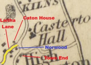
Extract of 1828 Hodgson map showing area around Norwood
The 1823 Greenwood Map of Westmorland
Curiously, the building does not appear on the 1823 Greenwood map of Westmorland (see below), but then, nor does Laitha Lane which was certainly in existence then.
Of note, on the 1823 map there is a small wood just to the south of the site of Town End. Is this the wood after which Norwood was named, i.e. a farm North of a Wood?
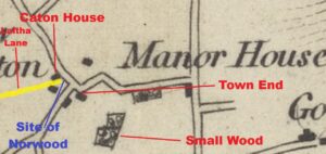
Extract of 1823 Greenwood map showing area around Norwood
The 1841 Census
As noted above, Norwood Farm does not appear in the 1841 census, but four properties referred to as ‘Town End’ do. Note that Caton House was also NOT listed in the 1841 census. The four different Town End residences are listed below with the names of the occupants, their age and status are as follows:
‘Town End 1’
Elizabeth Coates 85 Independent
Anne Coates 40 Independent
‘Town End 2’
Mary Taylor 70 Independent
Betty Huck 65
‘Town End 3’
Thomas Clarke 30 Independent
Lucy Wilson 25
Joseph Wilson 20
Edward Wilson 13 Lodger
‘Town End 4’
James Bayley 70 Farmer
Ann Bayley 65
Jospeh Bayley 40
Nicholas Bayley 25
From my prior research, ‘Town End 4’ is the original and current Town End. But what of the other three ‘Town Ends’ and their inhabitants? The tithe map of 1843 offers some clues. It records that there are additional buildings than those which appear on either the 1823 or 1828 maps referred to above. The tithe map was more than likely surveyed around the time of the 1841 census and so offers the best chance to try to understand the information in the 1841 census.
The 1843 Tithe Map of Casterton
The 1843 tithe map suggests that the buildings on the site of today’s Norwood Farm had been enlarged, but this was most likely a more accurate survey of the property.
As far as I can tell, this is the original Norwood Farmhouse on the site (today’s numbers 2 and 3 Norwood Farm Cottages).
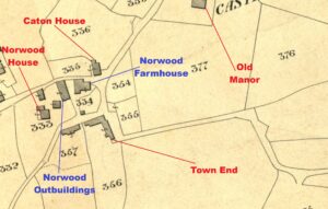
Extract of 1843 Tithe map showing area around Norwood
The table below summarises the owners and occupiers of the plots of land identified in the 1843 tithe records in the area around what became Norwood Farm.
| Tithe Number | Description | Owner | Occupier |
| 333 | Norwood Cottage – Shrubbery | Alexander Pearson | Thomas Clarke |
| 334 | Farm House & Yard | Alexander Pearson | Lambert Lawrence |
| 335 | Caton House – House | William Dodgson | Mary Dodgson and Betty Coates |
| 354 | Hospital Garden | Overseers of the Poor | Deborah Braithwaite |
| 355 | Orchard | James Bayley | James Bayley |
| 356 | House & Croft – Meadow | James Bayley | James Bayley |
| 357 | Garden – Garden | Alexander Pearson | Alexander Pearson |
The two annotated aerial photographs below from the 1990s and the tithe map, shown in the same orientation, show how the footprints of the buildings compare, with each building marked with a coloured border and a number.

Extracts of the 1843 tithe map (above) and an aerial photo early 1990s showing the area around Norwood Farm (below)

Tithe Number 333
This plot includes four buildings numbered 2, 3, 4, and 5 in the extract above, all of which still stand today. Alexander Pearson owned the properties, and they were lived in for many years by the Clarke family.[3]
Today, building number 2 is Norwood Farm Cottages 4 and 5. This building was on the same plot as number 5, which is Norwood House. Number 4 is today’s Beech Cottage and number 3 is today called Norwood Cottage. At some point in time, building number 2 became part of Norwood Farm, likely used as outbuildings rather than as accommodation.
Tithe Number 334
Plot 334 shows a small plot with a small building, number 7 on the extract above, which no longer exists. It is too small to have been a residence. Perhaps it was an outhouse or a pig sty.
On the tithe map it is not clear whether the larger building, number 1, today’s Norwood Farm Cottages 2 and 3, were part of plot 334. I shall assume that they were.
The tithe records shows that the owner of plot 334, described as ‘Farm House & Yard’, is Alexander Pearson. An 1829 directory lists an Alexander Pearson living in High Casterton, his job was recorded as a surgeon, other records however indicate he was living in Kirkby Lonsdale.[4] Below, we will discover how Alexander Pearson came to purchase these properties.
The person listed in the 1843 tithe record as occupying plot 334 was Lawrence Lambert. In both an 1849 and an 1851 trade directory, there is a Lawrence Lambert listed as a farmer at High Casterton. It would appear, therefore, that Lawrence Lambert was living and farming, or at least connected with what would later be known as Norwood Farm, from before 1843 up until 1851. I would assume, therefore, that the Norwood Farmhouse at this time was building 1: what is today’s Norwood Cottages numbers 2 and 3.
A Mysterious Lawrence Lambert
Lawrence was not the person listed at Norwood Farm in the 1851 census. That was the Wilson family (see later). I have identified four possibilities about who this Mr Lambert was, none of which is a convincing fit with the evidence. Firstly, there was a Lawrence Lambert who was born in Thornton in Lonsdale in 1784. In 1841 he was recorded as living at Melling with Wrayton, about 10 miles south of Casterton, with his wife and a son, also called Lawrence, aged 20.
In 1851, Lawrence senior was still at Melling with Wrayton, suggesting perhaps that this was not the Casterton farmer, unless he was sub letting Norwood Farm to the Wilson family. Perhaps then it was his son, Lawrence junior. In 1843, when Lambert was mentioned in the tithe records, he would have been 26 years old. He was not the eldest son and so would not have expected to be the heir of his father’s property. He was also soon to be married in November 1843 in Tunstall, to Mary Kellet. Perhaps then, he was setting himself up as a new tenant farmer in Casterton? However, the evidence also points away from him. His marriage banns state that he was living at Wrayton at the time and his soon to arrive children were not born in Casterton. In the 1851 census, he was recorded as farming at Tunstall.
There is a third Lawrence Lambert from this era. This one was born in Tunstall in 1787, making him 56 years old in 1843. In 1841 he was a farmer living in Sedbergh with his large family. Ten years later he was still living in Sedbergh suggesting that he had not spent any time in Casterton.
He too had a son named Lawrence who was 16 years old in 1843, surely too young to have set himself up on his own as a tenant farmer in Casterton. I cannot locate him in the 1851 census but in the 1861 census he was living in Billington in Lancashire with his wife and three daughters, aged seven, three and one, none of whom were born in Casterton.
Tithe Number 335
Plot 335 is Caton House, owned by William Dodgson and lived in by Mary Dodgson and Betty Coates. It is part of the ‘Town End’ complex noted in the 1841 census return. Elizabeth Coates, i.e. Betty, is listed in an 1829 directory as being a farmer in High Casterton.
Tithe Number 354
Plot 354 is called Hospital Garden. It was owned by the Overseers of the Poor whose Trustees were listed as Thomas Clarke, who lived at Norwood House and Nicholas Bayley who was related to James Bayley from the original Town End, and others.[5] The field was rented by Deborah Braithwaite who was living at Rock Cottage, near the Collier’s Lane crossroads.[6]
Tithe Number 355
Plot 355 is the field adjacent to Hospital Garden in front of the original Town End. It was owned and occupied by James Bayley. The field is still an orchard and is owned by the current owners of Town End.
Tithe Number 356
Plot 356 is the original Town End with the long plot of land behind it. It was owned and occupied by James Bayley. This is building number 6 on the annotated photographs above.
Tithe Number 357
Finally, plot 357 was owned and occupied by Alexander Pearson. It is today where the bungalow called Norwood Fields is located. The tithe map shows a substantial building in the field, but the narrative describes it as a garden. The building is not shown on the 1846 railway map nor the 1862 OS map.
Conclusion
Based on the above analysis, I can confidently draw conclusions about which properties on the 1843 tithe map are associated with those called ‘Town End’ on the 1841 census.
‘Town End’ 1 in the census
The 1841 census, (which does not include a house named Caton House), shows that Town End 1 has 85-year-old Elizabeth Coates living there with her daughter, 40-year-old Anne Coates. The 1843 tithe records document that living at Caton House were Mary Dodgson and Betty Coates, Betty being short for Elizabeth. It seems reasonable therefore to conclude that Town End 1 in the 1841 census was Caton House.
The Kirkby Lonsdale parish registers show that an Anne Coates was born on 21 February and baptised on 6 April 1794, the daughter of Richard and Betty Coats (Sic) of Chapel Houses. Betty Bayley married Richard Coates in 1780. In the marriage record, they were both recorded as coming from Casterton. Betty Bayley was the sister of James Bayley, the owner of the original Town End. Her husband Richard died in 1824, and Anne and her mother Betty (Elizabeth) were living together, close to their paternal relatives.
‘Town End’ 2 in the census
Living there in 1841 were Mary Taylor ,aged 70 and 65-year-old Betty Huck. I think that the house was either building number 1 or 2 in the extracts above, more likely number 1. There are more details about Betty Huck below.
‘Town End’ 3 in the census
Living at Town End 3 were Thomas Clarke aged 30 and his future wife Lucy Wilson aged 25. They were married in September 1841 and later moved into Norwood Cottage. Also listed as living at Town End 3 in 1841 were Lucy’s brothers Joseph and Edward. As noted above, Town End 3 was owned by Alexander Pearson who also owned Norwood Cottage. It would seem, therefore, that Town End 3 was property 2 above, which is in the footprint of plot 333.
Town End 4 in the census
Town End 4 is the original and ancient Town End lived in by farmer James Bayley and his family, wife Ann and their sons Joseph and Nicholas, Anne Coates’ cousins.
Before 1841
Using the assumptions above identifying the various Town Ends in the 1841 census, it is possible to draw some conclusions from analysing the large batch of ancient documents referred to above, which mention properties called ‘Town End’ in High Casterton but which were not, at the time, part of the original Town End, nor had been since before 1730, and quite possibly long before that.
My analysis of the documents suggests that there were two distinct properties with land referred to in legal documents as ‘Town End’ that were not the original Town End. The legal documents deal with various land matters including the sale of the land, the rent of the land or mortgages on the land. The author is not an expert in old property law and the documents are often difficult to read. Despite this it is possible to get a sense of what the documents were about. In some of the documents the name of fields are mentioned. When they are compared with the field names listed on the 1843 tithe map they can be identified.
To provide an overview, I have highlighted the fields associated with the different ‘Town Ends’ on the map below. Highlighted in yellow is the land that belonged to James Bayley and which was associated with Town End 4, the original Town End. This land holding is by far the largest shown. This supports the idea that the other two ‘Town Ends’ were offshoots from the original. I will now consider the legal trail derived from the batch of legal documents of the other two land holdings associated with ‘Town End’. I have coloured the fields in either orange or blue and refer to them below as either the ‘Orange Land’ or the ‘Blue Land.’

Annotated 1843 tithe map showing land holding belonging to three different Town Ends
The ‘Orange Land’ Ownership Trail
The land coloured orange consists of field numbers 358 and 331. In the tithe records field 358 is called ‘Well Close Fleets & Craggs’, recorded as being 10 acres, 1 rood and 8 perch. Field 331 is called ‘Town End Close’ recorded as exactly 2 acres.
In 1739, John Jackson senior, a Yeoman of Casterton, who had held the land since at least as early as 1730, borrowed £40 from William Robinson using as security his land called ‘Fleets, Well Close, Low Cragg and High Cragg containing by estimation 7 acres lying in Casterton together with the houses, outhouses, barn gardens…’. What was called Low Cragg and High Cragg in 1739 later became known as ‘Craggs’ (field number 358) in 1843.
There appears to be a discrepancy in the size of the fields. The land referred to in 1739 was about 7 acres whereas the same named fields in 1843 were just over 12 acres. This suggests that by 1843, a new field had been assimilated into one of the fields named in 1739.
In March 1754, John Jackson senior had died and his son, John Jackson junior had defaulted on paying the loan. Accordingly, a Thomas Jenkinson paid £70 to William Robinson, presumably to pay off the mortgage plus the accumulated interest, and an additional £194 and 5 shillings to John Jackson junior, thereby buying the ‘Orange Land’ on which the mortgage had been secured.
A complicated document from June 1761 ,with eight different parties involved, also mentions the ‘Orange Land’. Thomas Jenkinson had also defaulted on his loan. The complication arose because William Robinson, who had made the loan, had died. Furthermore, Jenkinson has also borrowed more money against either the ‘Orange Land’ or other properties or both, from Zachary Battersby and Sarah Gibson. Two people, Tobias Croft and Anthony Battersby, were appointed to sell the secured properties and then distribute the proceeds to firstly pay off the three loans and then pay any balance to Jenkinson’s other creditors.
Accordingly, they sold the ‘Orange Land’ and probably other properties and firstly paid off the mortgage of John Robinson, William Robinson’s heir, which was £374 plus interest. They then paid off the second mortgage to owner, Zachary Battersby, which was £340 plus interest, and then the third mortgage owner, Sarah Gibson, £505 plus interest. Finally, they paid the surplus to Thomas Chancery and John Sithe, the other creditors of Thomas Jenkinson. Dorothy Croft, a spinster from Kirkby Lonsdale, became the new owner of the ‘Orange Land’ i.e. the two fields and associated buildings.
A document from February 1769 records that Dorothy Croft sold the ‘Orange Land’ to Henry Threlfall, a Yeoman from Pilling in Lancashire for £440. The document also shows that John Singer and Joseph Bayley were the tenant farmers on the land. The ‘Orange Land’ was still described as ‘the Fleets, Well Close Town End Close and the Craggs containing by estimate 7 acres.’
The following document is from April 1783. Henry Threlfall is seen renting the ‘Orange Land’ to Thomas Huck (1), a Husbandman from Casterton, for a period of nine years. The document read as follows ‘The land consists of two houses and outbuildings and orchard and gardens. And closes called Town End, Jackson Crag (sic) Fleets and Well Close containing about 8 acres. They were now in the tenancy of Thomas Huck and Michael Cornthwaite. From 13 Feb 1783 for eatage, for Orchard from 5 April 1783, otherwise from 12 May 1783 for a period of nine years. Will pay annually £12 and 12 shillings.’ I assume that the field referred to as ‘Jackson Crag’ is the same as what was called ‘Low Cragg and High Cragg’ in 1739 and was later called ‘Craggs’.
Nine years later, in November 1792, Henry Threlfall and his wife Catherine sold the ‘Orange Land’ to Rowland Dodgson, a School Master from Thurnam, for £407 and 7 shillings. A land tax document from February 1799 records a farm called Town End in Casterton belonging to Rowland Dodgson, which was occupied by Thomas Huck (1). It consisted of one messuage, outhouses and 8 acres of land with common rights charged tax of 3 shillings and 8 pence and 3 farthings.
There is then a gap of 26 years before the next legal document mentions the ‘Orange Land’. In this time, Rowland Dodgson had died and his only son and heir, Jeremiah Dodgson, a Land Surveyor, sold the ‘Orange Land’ to Alexander Pearson in March 1825 for £1,220. The property was now described as ‘Fleets, Well Close, and Craggs containing 11 acres’, i.e. slightly larger, and an allotment in Casterton Fell containing 4 acres 2 roods and 3 perches. The property on the fell was number 450 on the tithe map named ‘Allotment Late Dodgson’, i.e. it had previously belonged to (Rowland) Dodgson.
As shown on the 1843 tithe map, Alexander Pearson still owned the field known as Fleets, Well Close and Craggs, and a field on Casterton Fell and the elusive Lawrence Lambert was the tenant farmer. In the tithe records, field number 358, Fleets, Well Close and Craggs is 10 acres 1 rood an 8 perch; and field 331, Town End Close, is exactly 2 acres.
This flow of documents shows that the parcel of land and a property (‘Orange Land’) known as Town End remained unchanged through the various owners from before 1730 to 1843.
As explained below, Alexander Pearson, clearly a successful surgeon judging by the land he was able to purchase, also ended up owning the ‘Blue Land.’ The next section shows how it ended up in his possession.
The ‘Blue Land’ Ownership Trail
These plots of land have a slightly more complicated history than the ‘Orange Land.’ The first record of the ‘Blue Land’ is from February 1740. The document is the will of Rowland Tatham, a Yeoman from Casterton, and a very substantial landowner in Casterton. On his death he left his estate to various members of his family rather than to a single heir.[7]
In the will, one parcel of land was described as the dwelling house called the Town End house with gardens, orchards, buildings and other appurtenances and parcels of ground. Two of the listed field names are no longer legible in the will, but by reference to later documents are called Elmsteads and Falsteads. The other fields mentioned in the will are, Croft, Croft End, Gill, Fleets Bown Birkett, Brockbank Mire and two closes called Braeslacks, all situated in Casterton. Rowland Tatham requested that trustees look after this land to ensure that his wife Elizabeth had an income from the rents. After his wife’s death the property was bequeathed ‘for the use and behoof’ of his granddaughter, Ellin Dodgson and her heirs and assigns for ever.
I cannot identify on the tithe map where the fields Fleets Bown Birkett, Croft and Brockbank Mire were located, as the names of the fields must have changed over the years. I can, however, identify Croft End (tithe map number 360), Gill (313), Elmsteads and Falsteads (389) and Braeslacks (306). These are coloured in blue on the map.
The next mention of the ‘Blue Land’ is in a document from April 1797. The document is between Thomas Huck (1) and his wife Eleanor (1), referred to in the document as a granddaughter of Rowland Tatham. It described the lands as Elming, Falsteads, Croft, Croft End, Fleet Bown Birkett, Brockbank Mires and Braeslacks. It consisted of one house, two barns, one stable, two cowhouses, two gardens, two orchards and 10 acres of land, 5 acres of meadow and 5 acres of pasture.
As noted above, in Rowland Tatham’s will of 1740, the property was first left in trust to his wife Elizabeth and then bequeathed to his granddaughter, Ellin Dodgson and her heirs. Ellin’s mother was Margaret Tatham. Margaret married John Dodgson. Ellin was born in 1733. I have found a record of an Eleanor Dodgson marrying a John Todd in Kendal on 17 October 1755. The marriage bond shows that Eleanor was 23 when she married, therefore born in 1732, and that John Todd was 21 years old.[8] On the face of it, it seems odd that Ellin (Eleanor) Dodgson chose to be married in Kendal rather than her home parish of Kirkby Lonsdale. Perhaps her chosen husband was not considered a suitable match for her.
In the Kirkby Lonsdale parish records, there is a 1760 burial record of John Todd whose mother was noted as Ellen Todd. No father is mentioned in the parish record. This implies the father had died before the child was born and that Ellin was a widow.
Eight years after she buried her son, Ellin (Eleanor) married again. The Kirkby Lonsdale parish records shows that Thomas Huck (1), a widower, married Eleanor Tod (Sic), a widow (1733 – 1817) of Casterton in 1768, thereby becoming Eleanor Huck (1). Thomas (1) had previously been married to Ann Hardy, and they had had children.
Fifty-Seven years after the will of Rowland Tatham, a document from April 1797, confirms this when it refers to Eleanor Huck (1) as Rowland Tatham’s granddaughter. She appears to be the owner of the ‘Blue Land’ and property.
Given that Eleanor (1) married Thomas Huck (1) in 1768, it would seem likely that the property listed in the 1777 Window Tax return, showing a Thomas Huck as owning a house with seven windows, is the same property.
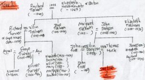
Tree 1 – Family tree of Rowland Tatham
The above mentioned 1797 legal document is quite complicated. It appears that there were disputes over the legal ownership of the ‘Blue Land.’ The document concerns a claim of ‘conusance de droit’, that is to say Thomas Huck (1) and his wife Eleanor (1) Huck (previously Todd and nee Dodgson) were asked to confirm at their own cost with ‘His Majesty’s Justices of the Court of Common Pleas at Westminster’ (a civil court), that they owned the property because a previous owner had given them title to it. Perhaps the dispute arose because both Thomas (1) and Eleanor (1) had previously been married and there were other children from their previous marriages.
Also in the document are the terms by which the property will be inherited from Thomas (1) and Eleanor (1). Three children were involved: Ann Huck, Thomas Huck (2), and Betty Huck (see Tree 2 below). Ann and Betty were left the property as Tenants in Common rather than Joint Tenants. This meant that when one died, they could separately pass on their share of the property to a named individual. Thomas (2) was also given some assets. An arrangement was set in motion whereby he would be paid £200 plus interest one year after the death of the last of either his mother or father.
Unfortunately, Thomas (2) predeceased both of his parents. Before he died, he had married a lady, also called Eleanor (2), and had had two children named Jane and Eleanor (3). The legal document stated that if Thomas (2) died before his parents and if he had children, then they would be entitled to the £200 in equal share.

Tree 2 – Family tree of Eleanor Huck, nee Dodgson
The ‘Blue Land’ is next mentioned in the documents in February 1821. It refers in detail to the 1797 document, summarising what was agreed in that document and then updating it to take account of subsequent events. By this time, Jane Huck, now of Bonefield Bank in Casterton, had reached the age of 21 (on 28 December 1820) and was therefore entitled to receive her share of the £200 plus interest. The document also notes that Ann Huck, the daughter of Thomas (1), was now married to John Sanderson, and that Eleanor (3) was also alive. A later document in June 1830 referencing the 1797 document notes that Thomas (1) died in April 1815 and his wife Eleanor (1) a few weeks later, on 7 May 1815.
Introducing John Wilman
In 1822, Jane Huck married John Wilman, a plumber and glazier from Lancaster. His business partner was Samuel Naylor, and their premises were on the west side of Penny Street.[9] They had at least two children, Alice and Thomas and possibly others.
A notice in the Lancaster Gazette in November 1829 offered for sale the former business of John Wilman, who had died, and Samuel Naylor.
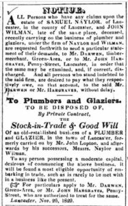
Notice of sale of business in the Lancaster Gazette in 1829
I presume that he and his family were in Lancaster at this difficult time. I cannot be certain when Jane and her children left Lancaster and moved back to Kirkby Lonsdale, but they did. The bereaved family cannot be found in the 1841 census, but in 1851, the son, Thomas Wilman, was living on Main Street, Kirkby Lonsdale with his wife and his sister Alice. Thomas had followed in his father’s footsteps; he was noted as being a plumber and glazier. Ten years later he had changed profession, he was listed as the Innkeeper of the Green Dragon, (now the Snooty Fox).
Their mother, Jane, does not appear in the records until the 1861 census when she was living in Tatham with her sister-in-law, Alice Atkinson. Ten years later she was living in Middleton with her daughter, Alice, who had married John Rigg in 1853.
In October 1828, Betty Huck (Jane’s aunt and Thomas Huck’s (1) daughter), a spinster, entered into an agreement with Alexander Pearson for the property known as Town End and fields known as Elming Falsteads, Croft, Croft End, Gill, Fleets Bown Birkett, Brock Bank Mires and Braeslacks now containing 22 acres (i.e. the ‘Blue Land’). Elizabeth Coates was living there as tenant. Alexander agreed to buy Betty’s half share of the property for £600. (Remember that the other half of the ‘Blue Land’ was left to Betty’s sister Ann, who had by now married John Sanderson.)
Several years later, Alexander Pearson eventually purchased the other half of the ‘Blue Land,’ but the purchase was not straightforward. A document from June 1830 refers to another document dated 26 March 1824, which stated that John Sanderson was an insolvent debtor who was being held in prison in Kirkby Lonsdale. He had appointed a Mr Henry Dance of Lincoln’s Inn in London to act on his behalf. The 1824 document appears to be establishing a situation whereby Ann’s share of the estate was separate from her husband’s, thereby protecting it from her husband’s creditors. In the document it states that John Sanderson and his wife Ann were minded that the moiety, i.e. the share of property to which Ann was entitled to, should be passed onto William Preston and Thomas Sarjinson as trustees. Thomas Sarjinson at the time was farming the original Gowrey Farm which was inside the Casterton parish border.[10]
In June 1831 John Sanderson had been given the ‘courtesy of tenure for his lifetime by ‘England’.’ This legal term, also known as “curtesy” or “courtesy of England,” gave a husband a life interest in the lands belonging to his deceased wife under specific conditions. The property referred to was ‘Town End’ in ‘Higher Casterton’ consisting of a farmhouse, stables and other outbuildings, a garden and orchard and 16 acres of arable and pasture plus an allotment on Casterton Low Fell containing 6 ½ acres lately in the occupancy of Betty (Elizabeth) Coates and now in the tenure and possession of Alexander Pearson.
In February 1834, Alexander finally got his hands on the second half of the ‘Blue Land’. Ann Sanderson, nee Huck had died in September 1833. Her husband was still living, as was their son and sole heir, Thomas Sanderson. Pearson agreed to purchase the second half of the property from William Preston and Thomas Sarginson, the appointed Trustees, for £520. The last remaining issue for Pearson was that Sanderson still had a right to live at the property, although by this stage, he was no longer residing in Casterton.
This chain of events meant that, in the 1843 tithe records, Alexander Pearson owned both the ‘Orange Land’ and ‘Blue Land’ as well as other fields in the area.
‘Town End’ 2
As noted above, living in ‘Town End’ 2 in the 1841 census were Mary Taylor, aged 70, and 65-year-old Betty Huck. It seems that although Betty Huck had sold her interest in the property to Alexander Pearson in 1828, she was still living there in 1841. Betty Huck died on 7 March 1851, a few weeks before the 1851 census, aged 78. In her death certificate the cause of death was recorded as old age.
1846 Railway Map
When plans were drawn up in preparation for building the railway that ran through Casterton, a few hundred metres to the east of Norwood Farm, detailed maps were drawn up. There is a significant difference between the 1843 tithe map and the railway map drawn three years later in 1846.
The later map shows that Norwood Farm had been extended to include the barn that runs along the lane towards Town End and a new farmhouse. The addition of these buildings significantly increased the size of the farm buildings, leaving them very much as the plot looks today.
This significant extension took place between 1843 and 1846. The owner, Alexander Pearson, was responsible for the extension. I presume that this was when the farm became commonly known as Norwood Farm, to differentiate itself from the original Town End Farm.
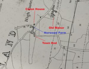
Extract of 1846 Railway map. Courtesy of the Cumbria County Archives (Kendal), WQ/RDP/78
1851 Census
As noted above, the first mention of the farm being called Norwood Farm is in the 1851 census. Perhaps, therefore, it was named after Norwood Cottage (now Norwood House) which was referred to as that in the 1841 census.
Farming at Hole House in Casterton in the 1841 census were the Wilson family, the same family who were listed as living at Norwood Farm 10 years later in the 1851 census.
Listed as head of the family was Thomas Wilson, a 50-year-old widower. An earlier trade directory lists Thomas Wilson as a farmer at Hole House in 1829. His wife Elizabeth ‘Betty’ Wilson, nee Shaw had died at Hole House from consumption (tuberculosis) on 12 January 1838 at 8 o’clock at night with her husband by her side. Betty therefore was not in the 1841 census.
Alongside Thomas in the 1841 census were his children. There was Margaret aged 24, Richard (23), Thomas (18), Joseph (16) and 11-year-old Henry. Thomas’ eldest son Edward had left his parents’ home, having married Margaret Atkinson in 1837 at Casterton church. Confusingly Edward’s wife Margaret was born in the same year as his sister Margaret (see Tree 3 below).
The 1851 census requested more details about individuals than those asked for in the 1841 census. Thomas was still a widower and had been born in Casterton. He was farming 100 acres. Still living with him was Joseph, now 26, also born in Casterton. His eldest sister, Margaret, who was now 34, had been born in Ingleton. There was also a new resident: Thomas’ 13-year-old granddaughter named Betty.
Betty Wilson, named after her paternal grandmother, was born at Hole House, Casterton on 18 January 1838, at 10 o’clock at night, only 6 days after her grandmother had died. Betty was Edward and Margaret Wilson’s daughter.
In 1841, the three of them, and Betty’s sister Sarah, were living at Preston Patrick. Sarah had been born at Barbon while her brother Thomas, born in 1842, was born in Preston Patrick. Another brother, James, was born in Orton in 1844 and another, Richard, was born in 1847 in Kirkby Stephen. It seems, therefore, that after they were married Edward and Margaret moved every few years, a disrupted life which was not made easier for Margaret when her husband died sometime after 1847 but before 1851.
As a result, the young family was broken up. This was why young Betty was living with her grandfather at Norwood Farm in 1851. Betty’s widowed mother, Margaret, had moved to Melbecks, Yorkshire to live with her widowed father, a shepherd. With her she took her other children, Thomas, James, and Richard, curiously all named in the census as Atkinson (Margaret’s maiden name) rather than Wilson. It is not clear where the other child, Sarah, was at this time. It is possible that she had died.

Tree 3 – The Wilson family tree showing the years (in red) when various generations of the family were listed in a census as living at Norwood Farm
1861 Census
Thomas, now aged 70, was still living at Norwood Farm as the head of the family and was farming 86 acres. With him was his unmarried daughter, Margaret, aged 44. Her role was listed as a dairy maid and housekeeper. His granddaughter Betty was still there, now aged 23, also a dairy maid. Norwood Farm was therefore a dairy farm.
Also in the house was Thomas’ daughter in law, Jane Wilson, nee Stephenson. She was visiting Norwood Farm with her newborn son Christopher, aged only 24 weeks, born in March of that year in Casterton. Jane had married Henry Wilson in Kendal in November 1860. On the day of the 1861 census, Henry was not far away. He was working for the Gibson family at Low Beckfoot, Barbon as a carter.
1862 Ordnance Survey Map
The 1862 OS Map specifically identifies Norwood Farm. Also on that map, it is clear to see that the outbuildings, which now form part of the modern Norwood Farm courtyard, were still associated with Norwood House.
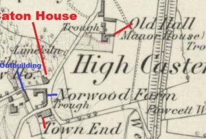
Extract of 1862 OS map showing the area around Norwood Farm
1871 Census
Thomas, by now a venerable 80 years old, was still farming at Norwood. The farm was now only 76 acres in size. Supporting him there were his children, Margaret and Richard, still both unmarried.
Also at the farm was another Margaret, Thomas’ grandchild aged 10 years, born in Ireby, the daughter of James Wilson and his wife Mary, nee Hobson.
In 1873, Norwood Farm appears in a trade directory, confirming that it was still being farmed by Thomas Wilson.
On 23 December 1875, aged 85, Thomas died in Casterton, at Norwood Farm. His cause of death was debility, meaning a weakness or feebleness or just plain ‘old age.’ With him at the time of death was his son Joseph.
1881 Census
Six years after their father died, Richard and Margaret were still farming at Norwood Farm. Richard was listed in the census as head of household, a farmer of 80 acres. Living with them was a 16-year-old farm servant, Thomas Walking, who was born in Kendal. In the same census, their brother Joseph was by now farming nearby at Bee Nest in Casterton. In previous censuses, he had been living with his wife Ann, nee Mason, and family in an unnamed property in High Casterton working as an agricultural labourer.
In an 1885 directory, siblings Margaret and Richard Wilson are noted as still farming Norwood Farm.
1891 Census
A decade later, the situation remained the same. Margaret, now aged 74, was listed as head and farmer. Her brother Richard, now 72, was the farm manager. They had one servant living with them. Robert Pikthall, an 18-year-old born in Kendal.
Margaret died on 6 February 1892. She was 75 years old. Her brother Richard was with her when she died. The cause of death was influenza and exhaustion. She had been living at Norwood Farm for well over 40 years.
Trade directories from 1894 and 1897 do not include Norwood Farm. However, they do list Wilson & Son at Bee Nest. Joseph Wilson had died in 1889 and so it was his widow, Ann, who was now running Bee Nest with her children, Bessie (32), Edward (27), and Mary (19).
1901 Census
In 1901 there was a new family farming at Norwood Farm, the Cowin family. The head of the family was 28-year-old Robert Waller Cowin, born at Westhouse, Yorkshire in 1872. With him was his wife Ellen Cowin nee Drinkall, aged 31, who was born in Galgate, Lancashire. There were three children. The eldest was Annie, born in Burton in Lonsdale in 1895. Next was Archie, aged three years, who was born in Casterton. This suggests that they had already moved to Norwood Farm by 1898, which seems probable given that in 1899 an advert was placed in the Westmorland Gazette announcing that Norwood Farm was available to let.
The notice mentions that Alfred Harris was the current tenant. He was the Bradford industrialist who had invested heavily in the area and was living at Lunefield House in Kirkby Lonsdale. This explains why Norwood Farm was not listed as a separate farm in trade directories from that era.
The property description in the Westmorland Gazette read ‘a very desirable mixed FARM called the NORWOOD FARM, situate at Casterton, near Kirkby Lonsdale, consisting of an excellent Dwelling House, with suitable Outbuildings, and about 80 Acres of Land, all situate in the Parish of Casterton.’[11]
The third child listed in the 1901 census was another son, just three weeks old at the time, named Robert after his father. Also in the house was a 36-year-old nurse, Jane Smith, who hailed from Ingleton. Jane would likely have been a wet nurse, helping the mother with the newborn baby duties.
By 1911 the family had moved on. They were farming in Burton on Lonsdale, but before then, their daughter, Margaret Elizabeth Cowin, was born in Casterton in 1908.
Trade directories in 1905 and 1906 confirm that Robert was farming at Norwood. However, a 1910 directory shows that a Thomas Lambert Hardacre was living at Norwood Farm. His occupation was listed as an insurance agent.
1911 Census – 1st entry
The 1911 census shows more details about the new family. Thomas is listed as head of the family at Norwood Farm. He is aged 35 and was born in Casterton. He was working for the Refuge Assurance Company. His wife Margaret Hannah Hardacre, nee Hall was with him. The census tells us that they had been married for 11 years and had two children, both born in Cowan Bridge. They were William George, aged 10 and Winifrid May, aged 9.
Thomas, who was born on 9 July 1876, was the son of William Hardacre and Elizabeth Ann Hardacre, nee Kimpton. William worked as a post messenger in Casterton. You can read more details about him in several of my previous sketches.[12]
1911 Census – 2nd entry
The 1911 census records a second family living at Norwood Farm, the Willan family. William was a farmer aged 69 and was born in Kirkby Lonsdale. His wife of 32 years was 52-year-old Dina Ann Willan, nee Foster. During their marriage they had had eight children but two had died. Just one child was still at home, 24-year-old John, who had been born in Tatham. A 1914 directory confirms that William was still farming at Norwood.
The fact that there were two independent families living at Norwood Farm suggests that there were now two distinct residences. They were what would soon be called East View, (now The Cornerhouse) and next to it, along Laitha Lane, the farmhouse, the two cottages, and the original farmhouse, which are now called number 2 and 3 Norwood Farm Cottages.
The Wilman Family – Eventual Owners of the Norwood Farm buildings
You may recall that we met John Wilman (1800 – 1829) earlier in this Sketch. He is the glazier and plumber operating in Lancaster before he either moved to Kirkby Lonsdale before his death, or his wife and children did so after his death. He was born in Giggleswick near Settle in 1800, as was his father William, also an innkeeper, before him, but the family had originated from Bolton by Bowland. John must have moved from Giggleswick to Lancaster as a young man to pursue his trade.
In 1822 he married Jane Huck (1800 – 1879) who has also featured in this story. She was the daughter of Thomas (2) and Eleanor Huck (2), and Betty Huck was her aunt. Through the Huck connection, it is possible to trace their lineage (see Tree 5 below) all the way back to Rowland Tatham, the substantial landowner who died in 1740 and, as described above, left his estate to members of his family including the land and fields that later became part of Norwood Farm.
The Annals of Kirkby Lonsdale note that, before they were farmers, the Wilmans were successful businessmen. They ran a thriving post and hiring business for horses and carriages, as well as holding the official contract for conveying the mail between Kirkby Lonsdale and Arkholme stations until 1928. They also provided a regular horse bus service to meet the trains and take passengers into town. Because they ran a large horse-drawn coach service, their business needed many horses and therefore required land on which they could pasture them. Hence the need to acquire land nearby at Chapel House.
For the greater part of the first half of the twentieth century three generations of the family owned the Royal Hotel in Kirkby Lonsdale. John ‘Shunt’ Wilman (1855 – 1943) moved there from the Green Dragon, now the Snooty Fox, in about 1910. As noted above, his father, Thomas Wilman (1823 – 1870) was recorded as a glazier and plumber in the 1851 census but was the innkeeper of the Green Dragon in 1861.
‘Shunt’s’ son John ‘Jackie’ Wilman took over the Royal Hotel in 1919 and ran it until 1946 when he in turn handed it onto his son, John Hodgson Wilman (1919 – 2012). This was soon after he had returned from war where, for most of it, he was a POW after being captured at Dunkirk. He continued running the Royal Hotel until 1953 when he decided to move to Chapel House Farm which they had previously let out to tenants.[13]
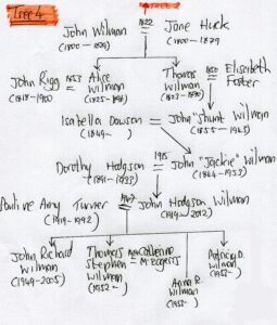
Tree 4 – The Wilman Family Tree

Tree 5 – the lineage from Rowland Tatham to Thomas Stephen Wilman, farmer at Chapel House
It was not until John Hodgson Wilman’s sons, John Richard and Thomas Stephen, acquired agricultural degrees from Newcastle University that the Wilmans actually farmed at Chapel House. Their father stayed at the farm until 1977 after which he moved to Kirkby Lonsdale. His newly married son John Richard Wilman (1949 – 2005) moved to the farm and he farmed it in partnership with his father and brother Thomas Stephen Wilman.
At some point in time, the Wilman family became owners of the lands that had belonged to Alexander Pearson including the ‘Orange Land’ and ‘Blue Land’. The family assume that they inherited Norwood Farm at some point but are not clear when.[14] Certainly it was after 1843, when Alexander Pearson was recorded as the owner in the tithe records.
The 1921 census below shows that the person living at Norwood Farm was working for J Wilman, therefore suggesting that the Wilman family owned it by then. The Wilman family still farm the fields that once belonged to Norwood Farm as well as those associated with Chapel House Farm. Thomas and Cathy still reside at Chapel House, although the business is now run from elsewhere.
Early 1920s – East View
The next record for Norwood Farm is a probate record for John Carr Bownass, who had died on 1 August 1920. He was only 29 or 30 years old. He was living at East View and had been an architect’s draughtsman. His estate was a little over £396. Probate was granted to a spinster named Dorah [Sic] Sproat.
The year after John Bownass’ death, his father and mother were still living at East View. His father, Edward, a retired farmer who had been born in Killington, was 79 years of age. With him was his wife, Jane, just over 67 years old, born in Wray with Bolton.
Edward died on 1 November 1924, still living at East View.[15] In the probate document, his estate was valued at £1,735. It was left to two spinsters, Josephine Baldin Carr and Dora Sproat.
Early 1920s – Norwood Farm
The 1921 census shows that there was a new family living in the original farmhouse, the Hirds. The head of the household was 45-year-old James Anthony Hird who was born in Gressingham Lancashire. He was employed by J Wilman from Chapel House Farm as a farm horseman.
Living with James were his wife, Mary Ellen Hird, four years older than her husband, hailing from Dent. There were four children living with them. There was Mary Alice Hird (18); Robert James Hird (17), a gardener and labourer working for Miss Bickersteth at Casterton Hall; John Hird (14), listed as out of work; and William Hird aged 13, a student. All four of them had been born in Kirkby Lonsdale.
A 1921 directory records that John Wilman is farmer at both Chapel House and Norwood Farm, confirming that James Hird was working for him. The same is noted in 1925 and 1929 directories.
The 1930s
By 1930, however, a trade directory from that year suggests that there is a new farmer living at Norwood Farm. John William Capstick and Bessie Capstick are recorded as farmers. John Captsick is noted again as a farmer in 1936 and 1938 directories.
The 1939 Census – Norwood Farm
The 1939 census confirms that there were still separate families living in East View and in the original farmhouse. The Capstick family were still in the farmhouse. John, who was recorded as a dairy farmer, had been born on 5 October 1895. His wife, Bessie, was born on 17 February 1900.
In the 1921 census, John was living at working as a horseman at Crake Trees, Whinfell. He was recorded as married, which must have happened just prior to the date of that census on 21 June 1921 because the record shows he was married in the second quarter of 1921. In the census, Bessie was still living at her parents’ house, in Selside, near Kendal, near to where her new husband was working.
Their daughter, Margaret E Capstick, was born on 27 April 1927 and was at school. A son, Norman R Capstick, was born in 1929, sadly dying age 17. A second son, Robert A Capstick was born on 20 November 1935. There was one other child who was listed in the 1939 census, but the details are redacted because they may still be alive.
The 1939 Census – East View
Living at East View was a new family. There was Fred Coward, born on 24 July 1895, in Dalton in Furness, a highway labourer. With him was his wife, Eliza Coward, nee Dodd, born on 9 May 1895 and a son, Leslie Coward, born on 9 March 1923, an agricultural worker. Two other persons were also in the house, but their details are redacted.
Fred Coward lived in the village until his death in 1972. For many years he was the local highway labourer and later a part-time postman. Their other children were Wilfred, Ronald, and one other.[16] The one other was possibly Elsie Coward. In 1948 she was reported as the only daughter of Mr and Mrs Fred Coward of East View. She had passed her State Registered Nurse qualifications, having previously attended Queen Elizabeth School in Kirkby Lonsdale. She later trained at the Royal Free Hospital in London.[17]

Sitting in the middle, around 1968, is Fred Coward with two old Casterton mates. On his left is Bob Wright, a long-term Casterton resident who had resided at Hole House and was later a caretaker at the village school; and on his right Bob Airey, originally a farmer at Middleton who retired to Casterton and was caretaker of the graveyard.[18]
A Gap in the Records
There is a gap of 27 years before either of the houses appear again in the records.
The 1960s
From a local newspaper, it appears that the Kitchen family were living at East View in 1966. They had placed an advert in the Lancaster Guardian selling a ‘half broken’ sheep and cattle dog.[19] In fact it was not the Kitchen family, it was the Kitching family, who placed another advert in 1968 selling a ‘USEFUL, cattle and sheep bitch for sale, two years old’.[20]
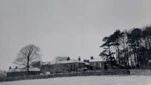
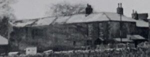
Photograph from the WI 1965 Scrap Book. The photograph taken from Manor House shows Town End on the left, Norwood Farm and Caton House.[21]
As part of a national WI initiative, the Casterton WI compiled a scrapbook for the village about the year 1965. Included in it was the photo above. The buildings appear in some state of disrepair. The roof on the barn looks like it may have tiles missing or growth on it, and the top floor windows of East View are bricked in.
From a Farm to Houses
In 1982, it was decided to sell Norwood Farm and East View for redevelopment. On 22 November 1982, the vendors, various members of the Wilman family (John Hodgson Wilman and Pauline Amy Wilman his wife, and their sons, John Richard Wilman living at Chapel House and Thomas Stephen Wilman living at Norwood), sold the property to Fred Hall & Sons, a local building firm from Whittington. The sale price was £50,000. This price included the field opposite the Barn known as Hospital Garden and the right to install a septic tank in a nearby field.[22]
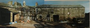
Norwood Farm under development in 1986. Courtesy of the author.
In time the complex was developed into six units. There was 1 Norwood Farm Cottages, also known as East View and now called The Cornerhouse. The original farmhouse had been divided into two houses, i.e. 2 and 3 Norwood Farm Cottages. The large building that had historically been associated with Norwood Cottage but later became part of Norwood Farm was also divided into two units, numbers 4 and 5. Finally, there was number 6, the Barn which had been built in the early 1840s.
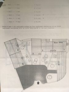
Plan of how Norwood Farm was divided into six units, with original selling prices from 1986/7. Courtesy of the author.
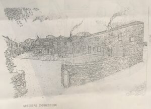
An artist’s impression of how the development would look from the original selling brochure. Courtesy of the author.

An artist’s impression of how East View and the rear view units 2 and 3 on Laitha Lane would look. From the original selling brochure. Courtesy of the author.
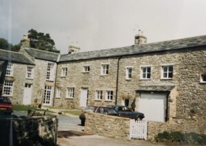
The Barn, East View and 2 Norwood Farm Cottages shortly after development in 1987 or 1988. Courtesy of the author.
Since 1987, many people have lived at Norwood Farm Cottages, with a variety of people living there either permanently, as second homeowners or long-term tenants. Under the deeds, none of the properties can be used for short-term lets.
The author’s parents-in-law bought the Barn in 1987 and the author and his wife visited it when it was under development in 1986. In 2017, the author and his wife bought the Barn from their mother / mother-in-law and redeveloped it. She moved into number 3 Norwood Farm Cottages, making her the last of the original owners from the new development and one of the persons to have lived longest at Norwood Farm,: 38 years and counting…
Simon Drakeford
August 2025
References
[1] See https://www.castertonparishcouncil.org.uk/sketch-of-town-end-farm-cottage-in-high-casterton/
[2] Cumbria County Archives (Kendal), WDPP/12/3/2
[3] A Sketch about Norwood House / Cottage can be found here – https://www.castertonparishcouncil.org.uk/norwood-cottage-later-norwood-house/ .
[4] Not to be confused with the Kirkby Lonsdale Solicitor Alexander Pearson (1870 – 1954)
[5] Records of this plot go back well before the tithe map. A long time ago, somebody gave the field for the benefit of the poor. There were other fields in Casterton also held for the benefit of the poor. The proceeds from renting the land were then given to the poor of the parish. It is not known why the garden is called Hospital Garden. I intend to research this field and the other fields held for the benefit of the poor in a future Sketch.
[6] For more details about Rock Cottage see https://www.castertonparishcouncil.org.uk/a-sketch-of-rock-cottage/ .
[7] In addition to the Town End land, he left a) two parcels of land called Smitherin and Burnett to his grandson George Turner, the son of Richard Turner, b) Cateon House (i.e. Caton House) and lands to his wife for life and thereafter to his granddaughter Elizabeth Dodgson, c) his house at Fell Yeat with land to be held in trust for his daughter Magdalen, the wife of John Dodgson and after her death to his grandson James Dodgson. Cateon House was available to Elizabeth for her life and would then pass onto his granddaughter Elizabeth Dodgson.
[8] The person who wrote the bond inscribed the number 2 so that it looked like a three, but when he wrote the number 3, it was clearly different to way that he wrote the number 3. Some family trees on Ancestry incorrectly think that she was 33 when she married.
[9] Lancaster Gazette, 19 September 1829, p2
[10] A Sketch about Gowrey Farm can be find at https://www.castertonparishcouncil.org.uk/gowrey/ .
[11] Westmorland Gazette, 10 September 1898, p4
[12] William Hardacre also features in sketches https://www.castertonparishcouncil.org.uk/a-sketch-of-blamires-grocery-store-and-post-office-later-known-as-pear-tree-cottage/ and https://www.castertonparishcouncil.org.uk/a-sketch-of-the-turnpike-road-after-1825-and-toll-bar-cottage/
[13] A. Pearson, D. Kyle, A. Phillips, and M. Gresson, The Annals of Kirkby Lonsdale and Lunesdale Today, 1996, pp296 – 300
[14] From email correspondence between Cathy Wilman and the author June 2025.
[15] Carlisle District Probate Registry wills, PROB/1924/W956
[16] 1965 Casterton Women’s Institute Scrapbook, Cumbria County Archives (Kendal), WDX 139/29
[17] Lancaster Guardian, 3 December 1948, p4
[18] Image and information from the 1965 Casterton Women’s Institute Scrapbook, Cumbria County Archives (Kendal), WDX 139/29, reproduced with the permission of the Casterton Women’s Institute
[19] Lancaster Guardian, 9 December 1966, p6
[20] Lancaster Guardian, 20 September 1968, p25
[21] Image and information from the 1965 Casterton Women’s Institute Scrapbook, Cumbria County Archives (Kendal), WDX 139/29, reproduced with the permission of the Casterton Women’s Institute
[22] Taken from a Deed of Conveyance held by the author.