

Introduction
Last month’s Sketch examined the history of the Turnpike Road in Casterton from when the Trust was first established in 1762 until the year before an Act of Parliament was passed in 1826 which inter alia legislated that a Toll Gate should be established in Casterton.
I am indebted to the previous research by Joyce Scobie about the history of the Sedbergh Turnpike Trust which was published in three parts in the journal of the Sedbergh Historian in the early 1990s.[1] Her research and working papers are deposited in the Sedbergh & District History Society’s meeting room in Sedbergh.
Casterton Comes On Board
The Act of 1826 was the fourth Act addressing the Sedbergh Turnpike Trust in which the Casterton section of the road lay.[2] The Act was passed in the 7th year of George IV’s reign ‘for more effectually repairing the Roads from Kirkby Stephen, High Lane Head, through Sedbergh to Greeta Bridge, and other Roads communicating therewith, in the several Counties of Westmorland, Lancaster, and York, and for diverting, extending and altering some of the said Roads.’
This Act required inter alia the addition of new turnpikes at Casterton and at Hay Fell, located on the road to Kendal. Soon after Hay Fell Gate was introduced, it took over from the original Toll Gate nearer Kendal named Barney Hills. The Trust’s Order book of 30 March 1830 notes that the gate at Barney Hills was removed and it was being referred to as the ‘old toll-gate’ as early as 1833.[3]
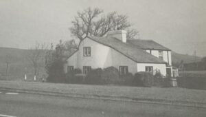
At first glance this may look like Casterton Toll Bar Cottage. It is in fact Hay Fell Cottage on the Sedbergh to Kendal road. It was built at the same time as Casterton and to the same plans[4]
New Gates
The Trust’s Order Book diligently transcribed by Joyce Scobie, offers glimpses about Casterton’s Toll Gate and Cottage.[5] For example, in the order book of 5 July 1826, it was recorded that ‘owing to small attendance the situations of 2 new Tollhouses on Hayfell and Casterton be considered at [the] AGM and [an] advertisement be put in the West. Gazette to that effect.’ The advertisement was duly placed for that meeting to be held on 5 September 1826.[6] The minutes of the Annual General Meeting recorded that it was ‘Ordered that a new Toll House and Tollgate be erected and set up by the side of and across the Road between Sedbergh and Kirkby Lonsdale between Colliers Lane End and Lathay [sic] Lane End in Casterton…’.
From 1829, the gate at Casterton was included in the triennial auction. The auction continued for a further 45 years.
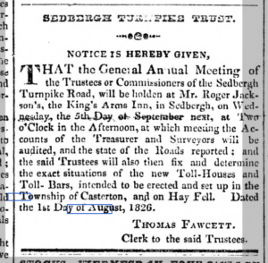
Notice of 1826 Annual General Meeting of Sedbergh Turnpike Trust[7]
A few months later, on 13 December 1826, it was recorded that after the erection of the Toll Gate at Casterton, a ticket from that gate could be used to clear (i.e. pass) the gate at Middleton Head and vice versa. There was concern that gates would operate at a ‘considerable loss’, because nobody had bid to run or ‘farm’ either of the new gates.
The gates were eventually let to John Long with the condition that a chain be placed across the north end of Wandles lane in Casterton. Assuming that Wandles Lane ended where it does today, at the crossroad where it turns into Bents Lane, it would appear that the chain was placed to ensure that traffic passing through Low Casterton and along Wandles Lane was not able to bypass Casterton’s new Toll House. To pass the chain on Wandles Lane, you would most likely have had to show a ticket obtained at either the Middleton or Casterton Gates.
The following December, the order book noted that money should be paid to Ralph Crofts for ‘Boards’ at Casterton and Hayfell, presumably the Toll Boards, listing the various Tolls that could be charged. In March 1828. Leonard Gibson was paid more than £4 for ‘Ironwork at Casterton’ and James Croft in excess of £19 for ‘Work at Casterton and Hayfellgate’. In September, the gate at Casterton required repair and a lamp was ordered.
These costs appear to have been incurred before Toll Bar Cottage was actually built. In September 1829 the Trust paid Lord Lonsdale 7 pounds and 10 shillings for land for Casterton Toll House.
Which McAdam?
In 1830 the Trust sacked its old Surveyors and appointed ‘McAdam’ at a fee of 52 Guineas. This was an interesting appointment. Scobie concluded that this was John Louden McAdam (1756 – 1836). He was notable for inventing the new process of “macadamisation” and who was a contemporary of Thomas Telford. As noted by Williams, it is true that John McAdam was heavily involved in Cumbrian Turnpike Trusts, at least eight by his count, but in 1830, McAdam was 74 years old.[8] It is therefore possible that it was John’s son James Nicoll McAdam (1786 – 1852) who was appointed as Sedbergh Turnpike Trust’s new Surveyor, he was indeed a Surveyor for many other Trusts. He was later knighted for his service to Turnpike Roads. He was still corresponding with the Sedbergh Turnpike Trust as late as 1850 on Trust matters.
Repair and Maintenance
The gate at Casterton appeared to have been troublesome. James Upton was paid 18 shillings to repair it in April 1834 and shortly after, in May, the sum of £1 was paid to the Superintendent Surveyor James Townsend for further repairs. In 1839, it was agreed that the Surveyor would seek tenders for ‘so much a stone [in weight] for sale of iron gate at Casterton and making a new oak one.’ One can only speculate as to why the gate required so much maintenance, was it careless drivers or disgruntled locals, reluctant to pay the Tolls?
The Order Book records that in May 1843, there was a discussion about ‘erecting a bar or chain across the Toll Road near Wanderer’s Lane at Casterton in lieu of the chain now there’. The proposal was discarded at the next meeting. This entry is curious. It appears that consideration was given to erecting a bar at the southern end of the lane on the Toll Road nearby Whoop Hall. The only Toll Road near Wanderer’s Lane, an alternative name for Wandles Lane, would have been the road from Kendal to Ingleton / Settle, which was administered by a different Trust.
Proposed Road 1
The 1826 Act identified several roads within the Sedbergh Trust that would benefit from being altered. One such was on the parish border between Barbon and Casterton. It read ‘And whereas some part of the Road leading between Sedbergh aforesaid and the Village of Casterton, in the Parish of Kirkby Lonsdale, in the said County of Westmorland, which is at present hilly and uneven, might be much improved if the following Diversion were made, (that is to say,) from at or near Lowfields [Farm] in the Township of Barbon, in the said County of Westmorland through Lands belonging to James Harrison, Joseph Gibson, and William Wilson Carus Wilson, Esquires, to or near to Flosk Brow [Flush Brow], in Casterton aforesaid.’
The plan of the diversion, shown annotated below, includes ‘Rawning Beck’ which on later maps is spelled Roanrigg Beck. On modern maps, Grove Gill Beck becomes Roanrigg Beck as it flows under the A683.
Old maps show that this section of the road was in existence as far back as 1770, eight years after the Sedbergh Turnpike Trust was established. It is not clear whether the road was built as a result of the establishment of the Trust or if the Trust took over an existing route.
As it happened, the planned change to the route did not take place. However, inspecting the lie of the land today, it is understandable why a new route had been proposed. The route at that time, and today, rises quite steeply when it leaves Casterton, just after the entrance to Casterton Grange heading towards Sedbergh, and then falls again just before Low Field Lane. The route that was proposed in 1825 avoided this hill, taking a flatter route along an existing line of fields. The proposed route would certainly have made it easier for carts and carriages to travel over, but for some reason, perhaps cost, it was not adopted.
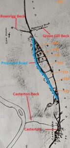
Annotated 1825 Plan to change the route of the Toll Road. The orange numbers are references to the field numbers in the Tithe Map.[9]
The numbers annotated on the copy of the proposed route above are the Tithe Map’s field numbers. We can see that some of the owners of the fields had changed between 1825 and 1843. William Wilson Carus Wilson remained owner of fields 222, 223 and 224 during this period. However, in 1843, James Harrison and Joseph Gibson no longer owned the fields along the route. The new owner was William Thompson who owned fields 209, 210, 211, and 203.

Above and below, the 1843 Tithe Map annotated in red to show the proposed route of the road
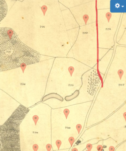
The map shown below, surveyed by Hodgson around 1823 – 5 and published in 1828 clearly shows the proposed route as a dotted line.
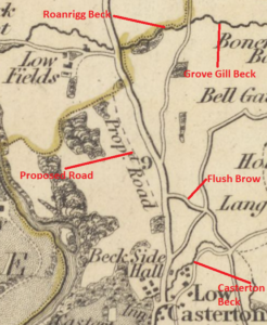
Extract of the 1828 Hodgson Map showing the proposed route of the road diversion
A Review of Where the Road Would Have Run
The photographs below illustrate the route that the road would have taken had the change happened. They were taken looking over the fields from the A683.
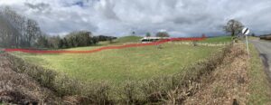
Photo taken near the milestone looking towards Sedbergh, tracking across the middle of the field before joining the field line beyond modern barn.
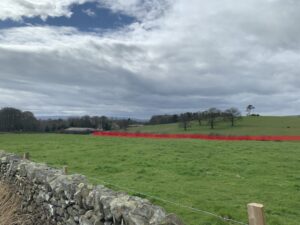
The route of the proposed road continues from the modern barn along field edge. Taken looking towards Casterton Grange.
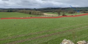
Proposed route of road continues along the field edge, Low Field Farm is top right just above the red line, see blue arrow. Looking towards Sedbergh.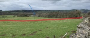
The proposed road joins up with the existing road just before Roanrigg Beck. Low Field Farm is indicated by the blue arrow
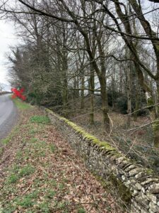
Looking towards Casterton, X shows the approximate location of where the proposed road would have rejoined the existing road
Proposed Road 2
On the same plan of the proposed changes above, there is a second intended diversion of the Toll Road in Casterton. This also did not happen. The plan shows that consideration was given to reroute the section of the Turnpike Road that runs from Colliers Lane to Devil’s Bridge.
This part of the village benefits from having been included in the 1816 Inclosure Map of Casterton. This map therefore predates the changes proposed in 1825. It also shows additional detail to the later Tithe Map. The Inclosure Map identifies individual fields located between the River Lune and the existing Toll Road that were to be inclosed. For example, field number 56 on the map below, owned by the devises of Bryan Burrow (he had died in 1813), was required ‘To fence against the Turnpike Road and Allotment 55’ which was to the north of field 56. The owner of plot 55, Arthur Robinson, was required ‘To fence against Turnpike Road and Allotment 50’ which was to the north of plot 55.[10]
It is clear then that in 1816, the Toll Road ran more or less along the course of the current A683 and may have done so before the road was turnpiked in 1762.
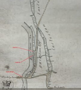
Extract of the 1816 Inclosure Map showing route of Toll Road, broadly along the route of the current A683[11]
The proposed route illustrated below, was to have the new road run from more or less where Toll Bar Cottage is now sited, along Laitha Lane, past what is now the golf course, turning right towards what is now the caravan site and at the junction with Chapel House Lane, rather than turn sharp right down the steep hill towards Devils Bridge, to continue and join the A683 towards Tunstall and eventually head on to Greeta Bridge.
As part of this change, it was proposed that the dog leg on Laitha Lane (which has its corner today where the bench is located), be removed and the road straightened.

Edit of 1825 Plan to change the route of the Toll Road[12]
Laitha Lane
The fact that Laitha Lane was not part of the Turnpike Road is confirmed by an entry in the Kendal Order and Indictment Book, 1798–1811 on 29 April 1808.[13] The record makes reference to a section of the highway in Casterton called Latham or Latholme Lane (i.e. Laitha Lane), beginning from the North side of the turnpike road from Kirkby Lonsdale to Ingleton (i.e. the current A65), where it crosses the turnpike road, and ends at the turnpike road from Kirkby Lonsdale to Sedbergh (i.e. the current A683). It states that that length of road is 1,298 yards (1,187 meters) with a width 8 yards (7.3 metres) and that it is ‘in great decay, and ought to be repaired by the township of Casterton’. This length is almost exactly the length of the road today from where Chapel House Lane joins the A65 to where the footpath ends next to the current entrance of Casterton Golf Course.
The reported width of more than 7 metres indicates that the road in 1808 was wider than it is today. I have measured the current width of Laitha Lane at various points and the width of the lane from the field side of the hedge or wall varies between 4 and 5 metres. The fact that it was so wide in 1808 may indicate that this was the original pre 1762 road that was superseded by the Turnpike Road. The Turnpike Trust choosing a new route would have some merit, because it does avoid the steep hill that the Laitha Lane route takes.
It is not hard to see why Laitha Lane would have fallen into disrepair in the years before 1808. Before there was a Toll Gate in Casterton, it would have been possible to travel from Low Casterton to Devils Bridge along the Toll Road for free, rather than using Laitha Lane, so the Parish may well have seen little point in maintaining it until they were ordered to do so in 1808.
The above comments raise the question, why did the Trust consider in 1825 changing the route of the Turnpike Road to run along Laitha Lane rather than keep the existing route that had been there since at least 1762. The consideration was presumably prompted by the addition of the Toll Gate at Casterton but I can’t think of a reason for using Laitha Lane, which is steeper and therefore more difficult for horse and carriages to use. The proposed change was never implemented, so on reflection, the Trustees could not justify the change either.
Half A Truth
My conclusion above, that Laitha Lane was never part of the Turnpike Road, does not agree with what Billy Makinson had been told. In his reminiscences he said that ‘Now then, a little bit about the Toll Bar [cottage]. Well, Toll Bar was nothing to do with the main road that came through [i.e. the A683], because there was no road went from Toll Bar to the Devil’s Bridge – the road went along the bottom of which is now the golf course – and came out at the top of Broken Brow and went down to the Devil’s Bridge.’[14] Billy’s reminiscences about the road -he moved to Casterton in the early 1900s as a young lad- would have come from what he had heard from older generations. The route described to Billy by his elders was actually the proposed route marked in blue above and was possibly the main route before 1762. Perhaps the section of road from Colliers Lane to Devils Bridge was newly built by the Sedbergh Turnpike Trust in 1762, replacing Laitha Lane as the main road by virtue of its flatter terrain.
Unfair Competition[15]
It should be remembered that travel by road in the nineteenth century was expensive and only the rich could afford to travel regularly by stagecoach. Toll charges were not the only costs that stagecoaches were subjected to. There was also a ‘mileage duty’, which was assessed on the number of passengers the coach was licensed to carry. This had to be paid irrespective of whether the coach was full or not.
As with all taxes, the tax payers were not happy about how much they had to pay. This was exacerbated when competition, even in the light of the improvement to road construction pioneered by McAdam and Telford increased. Initially, the increased competition came from the introduction of travel on canals. This mode of travel was also taxed, but less prohibitively than stagecoaches. The Sedbergh Trust was not too badly affected by the canal trade, canals did not encroach on their territory. In 1837, the government finally took note of the discrepancies between various modes of travel and substantially reduced the taxes on road travel.
The introduction of the railway was a blow to many Turnpike Trusts. The railway’s speed and capacity was hard to compete against. In 1840, a Parliamentary Report noted that 3 of the 10 Westmorland Trusts considered that they were adversely affected by railways. Once again, the Sedbergh Trust was not badly affected by this travel innovation. At least not until the railway line running between Clapham in Yorkshire and Tebay, known as the Ingleton Branch Line, opened in 1861, running through Casterton and Sedbergh.
The Next Act and Final Act
The 1826 Act was replaced by an 1851 Act of Parliament. The final Act was passed in 1874. In that year, a notice appeared in the newspapers announcing that the Sedbergh Turnpike Trust would expire in 1 November and that anybody with financial claims on the Trust should inform the Clerk of the Trustees.[16]
In fact all Turnpike Trusts ended on this day. Generally speaking, the reason that the Trusts were set up in the first place –to improve the road network– had been achieved. In 1874, the old Turnpike Roads became the responsibility of the County Councils.
Winding up the Trust
As part of its winding up, the Trust was required to sell all its assets including the Toll Houses. In March 1874, it was decided to firstly offer the properties to adjoining landowners. In the case of Toll Bar Cottage it was offered for the sum of £160.
On 27 May, the properties that had not been sold, including Casterton’s, were offered for sale by public auction at the Black Bull in Sedbergh. Toll Bar Cottage was sold to William Key for the sum of £154. William Key was a Farmer, Land Agent and Steward to William Wilson Carus Wilson, and was living at Old Hall which is featured in a previous ‘Sketch’.
The affairs of the Trust were steadily wound down, properties and land were sold, debtors chased and creditors paid. Once it was established that there were no further claims against it, the Trust was formally wound up on December 8, 1874. There remained a balance of £476 in the coffers. At the final Trust meeting held on 9 December 1874, it was agreed that the balance should be ‘paid and distributed amongst the Surveyors of the several Townships through which the said Turnpike Road passes according to the length of the Turnpike Road in each Township and that the statement be printed.’[17] It was further ordered that ‘a circular be sent to each Township informing them that a certain sum has been allowed for the repairs of the Roads in each Township.’ In the case of Casterton and its two miles of Turnpike Road, it was allocated the sum of 15 pounds, 12 shillings and 1 pence.
Casterton’s Surviving Milestone
In the Sedbergh Trust’s order book of 16 July 1840, it was ordered that ‘some person or persons to Tool Polish Cut and Paint the whole of the milestones upon the Trust [,] the milestones to be painted twice over [,] after they are cut the initials of the Town to which the road leads and the number of miles to each Town to be cut on each milestone and also the name of the Township on each milestone.’
There were milestones prior to 1840. The 1825 map of the proposed changes to the roads discussed above indicates the position of milestones. The 1840 order therefore is either for new replacement stones or, perhaps, the refurbishment of existing stones.
There were two milestones within the parish boundary of Casterton. One still remains, just by the entrance to Casterton Grange, and it matches the 1840 description above indicating that the stone in situ is more than 180 years old. The stone’s current location is in the original and correct location as confirmed by the stone’s position marked on the 1919 OS Map. The numbers cut into the stone, 9 miles from Sedbergh and 1¾ from Kirkby Lonsdale, tally with the distances today.
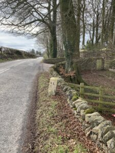
Casterton’s Milestone near the entrance to Casterton Grange looking towards Casterton
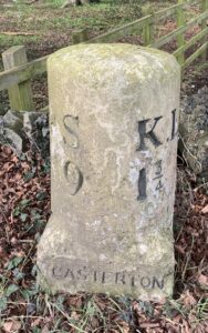
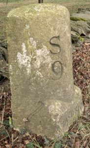 From top to bottom, the milestone as it appears March 2023 looking towards Casterton, face on and looking towards Sedbergh
Casterton’s Missing Milestone
The 1862 OS Map also noted the position of milestones. It shows that the next milestone towards Devils Bridge was located just before Low Lodge Cottage. On the map, it records that the milestone correctly shows that Sedbergh is 10 miles away but inexplicably suggests that Kirkby Lonsdale is 2¾ miles away. The 1899 OS Map corrects this error, showing that Kirkby Lonsdale is actually ¾ mile away. If anybody knows where this stone is, please let us know!
Toll Bar Cottage
As noted above, Toll Bar Cottage was originally built by Sedbergh Turnpike Road’s Trustees around 1828. The Cottage is identified as a Toll Booth on Hodgson’s 1828 Map. As noted above, this is the year before the Trust paid Lord Lonsdale for the land – perhaps the map was anticipating the building or Lord Lonsdale accepted late payment. The Trust was noted as owner of the building on the 1843 Tithe Map.

Toll Bar Cottage C 1887 from Magic Lantern Slide Series Ingleton and its Waterfalls[18]
An Accident – 1
As described in last month’s sketch, accidents did happen on the Toll Roads, the 1819 one being an example. More were to follow at the new Toll Gate at Casterton.
On Wednesday 7 March 1832, there was a fatal accident at the Gate. The driver of the coach, William Robinson, pulled up his horses at the gate for a few minutes, leaving them under the control of ‘a little boy’. When one of the horses became restless, the boy called out to Robinson who was only a few yards away. Robinson immediately ran towards the horses and grabbed the reins, frightening them into running off. Robinson kept hold of the reins and ran alongside the wheels of the coach, hoping to stop the startled horses. Tragically, one of the horses struck Robinson on the thigh and he fell to the ground, whereupon two of the coach’s wheels ran over his prone body breaking his arm near the shoulder.
Meanwhile, the horses, coach in tow, bolted and proceeded along the road and galloped across Devil’s Bridge and into town, much to the amazement of startled onlookers. Rather than stopping at their usual stop, the Rose and Crown (now The Royal Hotel) on Main Street, they pushed forward to the end of the street. According to an account of the accident told by George Harrison, whose ancestors were in Kirkby Lonsdale at the time, the horses were trying to get to where they were fed, round the back of the Red Dragon, but were unable to turn right down Mill Brow and instead crashed into the front window of Kimberley House (now Platos).[19]
Despite receiving prompt medical attention, and initial hopes that he would survive, Robinson endured until six o’clock the next morning before succumbing to his injuries. He left a widow and a large family. Shocked by the tragedy, funds were raised locally for the family.[20]
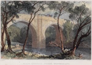 Print of Devils Bridge C 1834 by Allom. Author’s copy.

Detail showing Coach crossing bridge, C 1834 by Allom. Author’s copy.
The Tollkeepers
It was not uncommon for a single person to bid for multiple gates within a Turnpike Trust and this was the case for Casterton. As noted above, the first ‘Toll Farmer’ at Casterton was John Long who paid a total of £620 per annum for all of the Trust’s gates, paying the same amount in 1829. John Long therefore would have hired his own gatekeepers. In 1832, a group of four men paid £704 for all of the gates. In subsequent years, different groups of men combined together to acquire the rights to collect the tolls.
The 1841 Census recorded the Casterton Tollkeeper as George Elleray (36), living with his wife Grace (25) and Agness [sic] Elleray (35), perhaps George’s sister, and children Mary (11) and George (1). In that year, George was one of a group of three men who bought the rights to the Tolls for £780. From 1851, Charles Winn acquired the rights to all of the Trust’s Tolls and, with exception of one auction in 1856, he continued in this capacity until the final auction of 1873.
By 1851, the Elleray family had moved to Cabus near Preston to a different Toll House. It appears that he made a success of his Toll keeping. The 1861 Census shows him living with his wife and numerous children at Beast Banks, Kendal, his occupation recorded as a landed proprietor. He died in 1871.
An Accident – 2
In 1851, Toll Bar’s new residents were Sedbergh born Toll Keeper Thomas Herd (49), his wife Margaret (51) and children Mary (17), Richard (14) and Edmond (12). Not on the Census was their son Edward, he had tragically died the previous year. He had been playing with a cricket ball outside the cottage and was so focussed on the ball, he did not notice a horse and gig on the road. He fell in front of the alarmed horse which reared up, fearfully injuring the boy’s head, leaving him with no chance of recovery.[21] His father Thomas died not long after in 1855.
In 1861, Richard Close (57), born in Claughton, was the Toll Collector with his wife Ann (58) hailing from Caton, daughter Anne (25), recorded as a dressmaker and Isabella (11). Ten years before, Richard had been a gardener living at Hay and Hutton in the Hay near Kendal. Ten years later he was listed as a Twill Maker living at Bare and Poulton near Morecambe. By 1881, he had returned to his place of birth and was weaving baskets with his wife in Lancaster.
An Accident – 3
In July 1865 there was another fatal accident at the Casterton Toll Gate, once again, involving the Lord Exmouth coach. The coach’s horses took fright and galloped off, one of them knocked over the unnamed driver and the coach passed over his body. He died a few hours later.[22]
In 1871, the last person listed as Toll Collector living at the house was Joseph Wood aged 80 and his wife Grace (82). Sharing their house was granddaughter Martha Benson (22). They were experienced Toll Collectors. Ten years earlier, he had been a Toll Collector at the Plumgarth Toll Gate at Strickland Ketel, north of Kendal, in 1851 he was collecting tolls at Scalthwaiterigg, also north of Kendal, and in 1841 he had collected the tolls at Milnthorpe.
Poor Maintenance
In 1879, only 5 years after being handed to the County, our road was mentioned at the Westmorland Midsummer Quarterly Sessions. In a report on the state of the roads in the County, it was noted that, ‘Sedbergh Turnpike Road – The portions of the road running through Casterton, Barbon and Middleton… are getting very bad. The road in the three first named Townships is becoming very hollow, and will, unless attended to, be little better than a water course. There ought to be at least 100 cubic yards of stone per mile put on.’[23]
Problems were also noted in 1909 when the Casterton Parish Council wrote to the South Westmorland Rural District Council to complain of the ‘bad state of roads in the parish’.[24]
Long Term Local Residents
In the 1881 Census, William Hardacre (43) was living at the Cottage with his wife Elizabeth (39), and two children. William had previously resided at the Old Post Office (now Ghyll Cottage), the son of William Bownass Hardacre. In the 1891 Census, William was retired, but was still living at the cottage with his wife and children.
Toll Bar Cottage, called Gate House in the 1901 Census, shows that James Thompson, a road labourer (59) was there with his wife Margaret (49) and their 13 year old son Walter who was an ‘Under Gardener (Domestic)’. We know that James was there at least as early as 1899, see below. The 1911 Census shows that James and Margaret were still living in the cottage. Margaret, by now a widow, was living there in 1921.
Cyclists in the Dark
In 1894, two Sedbergh youths, Joseph Nelson and Thomas Iveson were separately charged at the Kirkby Lonsdale Petty Sessions for riding their bikes without lamps on the highway between Casterton and Kirkby Lonsdale. Police Constable Hardon reported that Iveson said that his lamp bracket was broken and that he was unable to get it repaired whereas Nelson told the Officer that the spring attached to his lamp was faulty and his lamp wouldn’t stay on. Their stories were not believed and they were fined 5 shillings and 7 shillings and 6 pence respectively plus costs!
Change of Owners
We know that in 1874 William Key had bought Toll Bar Cottage from the Sedbergh Turnpike Trust. At some point it had been purchased by Alfred Harris, perhaps from Key or perhaps from somebody else. In June 1899, there was an auction which included properties in Casterton that had belonged to the, by now deceased Alfred Harris. Alfred, who was a wealthy banker from Bradford, had previously bought and demolished the original Lunefield in Kirkby Lonsdale and rebuilt it into a much grander property.
Toll Bar Cottage -Lot 9- was sold at the auction as part of the large Lunefield Estate Sale and included other properties and land within Casterton such as Brownthwaite Fell, Galebeck Allotment, Smithy House, Town End Farm, Bee Nest, Casterton Old (Manor) Farm, Cragg House Farm, Rock Cottage, and Elm Tree Cottages.[25] Intriguingly, as well as buildings, there was a run of nine plots of land from the A683 along the south side of Colliers Lane up to Lane End Cottage listed as ‘building plots’.
Lot 9 was made up of Toll Bar Cottage and ‘Another Superior Building Plot’ of just over two acres. The auction catalogue states that it was rented to a Mr [Thomas] Thompson on a weekly Tenancy of 6 pounds 10 shillings per annum. The Lot was described as ‘Capitally adapted for conversion into a Lodge to guard a carriage approach to the [yet to be built] property. It contains Sitting Room, Kitchen and Two Bed Rooms.’
Five years later, a number of the properties were sold at auction again, including Toll Bar Cottage, but none of the building plots, they remain fields to this day.
The properties in the 1903 auction included Casterton Old Manor Farm, (this would have been the auction after which the Makinson family moved in), Cragg House Farm, Town End House and Lot 2, The ‘Old Toll Bar’ Cottage.
Once again, the catalogue described Toll Bar Cottage as having a sitting room, kitchen and two bedrooms. It notes that ‘Belonging to this Cottage, and included in the Sale, is a right of drawing water from the stream on the opposite side of the road (which is piped and collected in a small water tank), with a right of way thereto.’[26]
A War Hero
The 1939 wartime census recorded that another general labourer was living at the house, 66 year old John Parker, known as Jack, with Mary Elizabeth his wife, 20 years his junior. During the war, they received the terrible news that their son Corporal Thomas Parker had been killed during the invasion of Normandy on 24 July 1944. Thomas had joined up in January 1940 aged 22. He survived the British Expeditionary Force defence of France and the evacuation at Dunkirk. He then spent time in Iceland prior to participating in the D-Day landings. He left a wife and 16 month old daughter. His name is recorded for posterity on the Casterton War Memorial.
In 1945, Mrs J. Parker sold Toll Bar Cottage to the Underley Estate for £500.
The Teashop
Taken during World War Two, the photo below shows a Miss Elizabeth Taylor on the right and her niece Miss Elsie Taylor. Elizabeth lived in Casterton at Loftwood. The photo was published in the Westmorland Gazette in 1991 with information about Toll Bar Cottage. It noted that at the time of the photo, John ‘Jack’ Parker was retired but, ‘did a bit of hedging and walling for local farmers.’ His wife Mary sold cigarettes and sweets and prepared teas for visitors to the village from Kirkby or visiting parents of girls from the school. In his reminiscences, Billy Makinson recalls the farm hands sending him to the Cottage to buy their cigarettes.
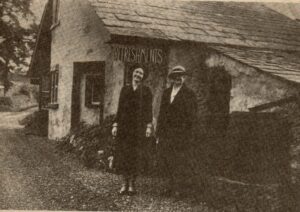
Toll Bar Cottage during World War 2
Latterly
The 1968 Women’s Institute Scrapbook noted that a Mr and Mrs John Wharton were living at Toll Bar Cottage with their young baby.

Toll Bar Cottage following a snow fall in December 1981
Simon Drakeford
April 2023
With thanks to Joyce Scobie
References
[1] Unless otherwise noted, this Sketch draws from, J. Scobie, History of The Sedbergh Turnpike Trust, Sedbergh Historian, Vol 2 (1991) pp 41 – 4, Vol 3 (1992) pp42 – 47 and Vol 4 (1993) pp31 – 35
[2] 7 George IV, c. 72, 1826
[3] Westmorland Gazette, 19 October 1833, p3
[4] J. Scobie, History of the Sedbergh Turnpike Trust, Sedbergh Historian, Vol 4 (1993), centre pages
[5] Copies of Scobie’s working papers can be viewed at the Sedbergh & District History Society’s room in Sedbergh
[6] Westmorland Gazette, 26 August 1826, p3
[7] Westmorland Gazette, 26 August 1826, p3
[8] Road Transport in Cumbria in the Nineteenth Century, L. A. Williams, George Allen & Unwin, 1975, p70
[9] Courtesy of West Yorkshire Archive Service, Wakefield, WRT82
[10] On the 1843 Tithe Map plot 55 was numbered 286 and called Water Brow. It was owned by Elizabeth Robinson and occupied by George Capstick. Plot 56, numbered 285 on the Tithe Map was called Water Brow Wood. It was owned and occupied by Alice Burrow who was most likely the widow of Bryan Burrow. A Bryan Burrow of Casterton married Alice Huck in 1810 in Kirkby Lonsdale.
[11] Courtesy of the Cumbria Archive Centre (Kendal), WPR 19/14/1/1 Inclosure Award: Casterton 1816
[12] Courtesy of West Yorkshire Archive Service, Wakefield, WRT82
[13] John F. Curwen, Records Relating to the Barony of Kendale Volume III, CWAAS, 1926, p294
[14] The fascinating reminiscences can be found here https://www.castertonparishcouncil.org.uk/wp-content/uploads/2021/10/Billy_Makinson_reminiscences.pdf
[15] This section taken from Road Transport in Cumbria in the Nineteenth Century, L. A. Williams, George Allen & Unwin, 1975, Chapter 4 – Competition for Traffic
[16] Yorkshire Post and Leeds Intelligencer, 17 August 1874, p1
[17] Sourced from copies of the documents held at Sedbergh and District History Society’s History Room, original source West Yorkshire Archive Service (Wakefield)
[18] Courtesy the author
[19] You can hear his account here https://www.kirkbylonsdalehistory.info/?s=george+harrison
[20] Lancaster Herald and Town and County Advertiser, 10 March 1832, p5
[21] Westmorland Gazette, 3 August 1850, p3
[22] Westmorland Gazette, 22 July 1865, p6
[23] Kendal Mercury, 4 July 1879, p8
[24] Westmorland Gazette, 16 January 1909, p3
[25] Cumbria Archive Centre (Kendal), WDB 22/2/1/12, Catalogue of sale of properties of Lunefield, Holme House and Casterton Estates, 15 June 1899
[26] Cumbria Archive Centre (Kendal), WDB 22/2/1/18, Catalogue of sale of properties in Casterton, 8 October 1903