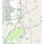
Location map
Casterton and High Casterton as shown on Google maps.


Casterton and High Casterton as shown on Google maps.
Most, if not all, properties in Casterton do not have a street name and number so can be hard to find. To help visitors and locals we have commissioned maps showing every property in the village. To achieve the required level of detail the parish has been split into three.
The data collected was transferred onto the maps by Dr. Colin Day, and the Parish Council gratefully acknowledges his painstaking work.
Every named dwelling in the parish is shown, as of 10th January 2025.

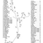

Road and lane names shown are those in the official gazetteer, and are the ones used by residents, but only Laitha Lane, Chapel House Lane, Collier’s Lane, Fern Croft and Smithy How have street nameplates in place.