

Introduction
Following on from my Sketch about Casterton’s Lime Kilns a few months ago (see a-sketch-of-castertons-lime-kilns), this Sketch looks at the history of our solitary Malt Kiln.
When I started writing this Sketch I was expecting it be quite straightforward. However, the field in which the Malt Kiln was located and the farmer’s estate in which the field was located were the subject of numerous documents dating as far back as 1734. The fields passed through several different hands through the centuries via both inheritance and sales.
The historic documents suggest that the field was at various times part of Holly Bush, Bee Nest, possibly Town End, the one in Low Casterton opposite the Pheasant, and possibly Cragg House in High Casterton, which also might have been called Town End. I am still unravelling this information and will present it in future Sketches.
For the purposes of this Sketch I will make reference to the documents but the narrative may contain some supposition, uncertainty that I hope to clear up in future Sketches about the above mentioned properties.
An Introduction to Malt Kilns and Maltsters
The earliest evidence of there being a Malt Kiln is Casterton is 1734. From the records, it appears to still have been in use until the mid nineteenth century.[1]
Malt kilns in rural areas during the eighteenth century were typically small-scale operations, often located on farms. These kilns were often simple structures, reflecting the relatively low-tech nature of rural industry at the time and were prone to uneven heating, leading to inconsistent malts.
Barley is the most used grain in brewing. Before it can be used it needs to undergo ‘malting’ to convert its starches into fermentable sugars. This process involves soaking the barley in water, allowing it to germinate, and then halting the germination by drying the grain in a kiln. The drying process is crucial for producing the right flavours, colour, and texture of the malt, which will, in turn, affect the quality of the beer.
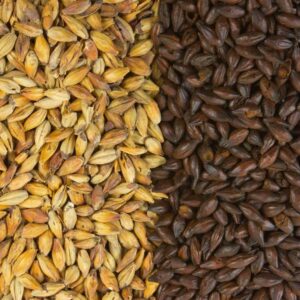
Different types of Malt will give different flavour beers
By the mid-eighteenth century, the “underfloor” design for malt kilns became more common, even in rural settings. In this design, hot air from a fire below the floor was channelled upward through the grain bed, providing a more uniform drying process. This innovation helped Maltsters in rural areas achieve more consistent results and allowed for larger quantities of malt to be produced.
By reference to maps and LIDAR imagery (see below), the site of Casterton’s Malt Kiln appears to have been what is now slightly in front of a mound in the field. The mound may be the remnants of the dismantled kiln. It is likely that most of the stone used in the building was reused in other buildings.


The approximate location of the Malt Kiln in 2024 in Redhead field [2]
It is not possible to say how simple or sophisticated the design of the Casterton Malt Kiln was. Stope wrote that ‘The simplest form of multi house possessing any capacity for work is a plain two-story building, having attached to it a kiln or drying house, and consisting of a ground floor of clunch,[3] a brick steeping system, and a first-floor of timber, with or without partitions for separating the stored grain or malt… Houses of this class were at one time extremely numerous, and great number still exist.’[4]
Looking at the footprint of the Malt Kiln on the 1846 Railway map noted below, and by comparing it with other extant buildings, and by referring to the map’s scale, the Malt Kiln building seems to have been at least 15 metres long and 8 metres wide. A basic malting operation would require a kiln, a cistern for steeping the barley, a place to store the untreated barley and the malt in sacks. Stope describes how such a building might be operated.
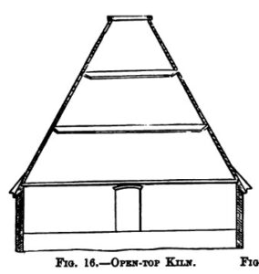
Casterton’s Malt Kiln possibly looked like this ‘Basic Open Top Kiln’[5]
‘In many cases houses of this size are worked entirely by one man, who, for the four summer months, commonly follows some other craft, such as thatching, bricklaying, or the like. When malting commences in October, his duty is to receive the barley, screen and pass it into the cistern, steep, couch, and floor it, raise to the kiln and dry it, tread, screen, store, again screen it, and measure into sacks for use. All this, involving constant attention, skill and care.’[6]

A nineteenth century steeping cistern[7]
In the eighteenth century, agriculture formed the backbone of rural life, and barley was one of the most important crops. While much of it was used for animal feed, a significant portion was cultivated specifically for malting and brewing. The income generated by malting offered rural areas a chance for economic diversification.
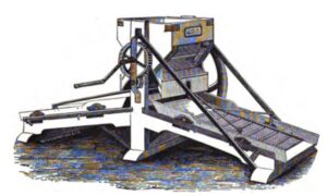
A basic barley screening / sorting machine[8]
By the early eighteenth century, malting was already a well-established practice, but it was not until the 1700s that the industry began to experience more formal regulation, partly in response to public health concerns and the growing influence of governmental tax policies.
In Britain, the government recognised the importance of malt and beer production as an effective source of tax revenue. For centuries malt and malt production were subject to taxation in different forms. In 1697, the English government introduced the ‘malt tax’, which imposed a levy on the production of malt, this tax remained until 1880, albeit with extensive tinkering with the rules. The tax was repealed in 1880 and replaced by a duty on beer.
Field Changes
Through the centuries, many of Casterton’s field’s boundaries were unchanged. This is not the case with Redhead, the field in which the Malt Kiln is located. A review of old maps illustrates the changes.
The 1843 Tithe Map
Casterton’s Malt Kiln is in a field just off Wandales Lane, northeast of Bee Nest Farm. On the tithe map (below) the kiln is in field number 158. The tithe records show that the field was then owned by Wilson William Carus Wilson and that the tenant was Thomas Atkinson who was the tenant farmer with Bee Nest Farm.
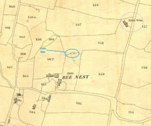
Extract of the 1843 tithe map showing the Malt Kiln and nearby Lime Kiln
The 1846 Railway Map
The Malt Kiln is also shown on the maps that were prepared for the construction of the railway that went through the parish of Casterton. The maps indicate the proposed route of the rail track through the village.
On the map, fields and other premises were allocated a number. The field number was listed in a document which showed who the owner and tenant were, together with a brief description of the land. The Malt Kiln was allocated number 37, it was owned and occupied by James Carter. The description was ‘Maltkiln yard outbuilding and yard’.
The field in which the Malt Kiln was located was given the number 36, this is the same as the field numbered 158 on the tithe map. As in that map, it was owned by William Wilson Carus Wilson and occupied by Thomas Atkinson. It appears therefore that the Malt Kiln was a separate asset to the field in which it stood. This is confirmed in a will written by Robert Cragg in 1818 which bequeathed the Malt Kiln to his son-in-law John Carter, and specified in more detail how the access to the Kiln through the field was arranged.
‘all that my Malt Kiln situate in Casterton aforesaid now in the occupation of John Carter and the ground and soil whereupon the said Malt Kiln stands with a right of Road to and from the same from and out of Car Lane together with eight yards of land in breadth on each side of the said Malt Kiln or as much thereof as can be got without removing any of the fences.’[9]
Also of note is the description of the field number 37 in the railway map. It refers to it being a ‘Field (,) stream and occupation road’. The stream is not visible in the field but if more prominent in these times could have been a useful source of water for the malting process.
Occupation Roads
The term ‘occupation road’ was frequently used by railway surveyors to describe paths or roadways over which both public and private rights of access existed, and which were jointly owned and occupied by township officers and private persons. The term had no legal definition and was subject to a good deal of legal debate over the years.[10]
The occupation road in field 36 was at the far end of the field away from the Malt Kiln giving access to the Lime Kiln (34 on the map) from Bee Nest Farm (see below). In this case, by presumption it indicates an old public right of way.
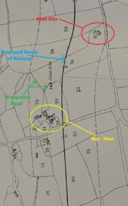
Extract of the 1846 map of the proposed railway through Casterton[11]
The 1862 Ordnance Survey Map
The Malt Kiln is also shown on the first OS Map of Casterton which also shows the now completed railway. Note that it incorrectly refers to Bee Nest as Bees Nest. Also of note is that the fence or hedge that divided fields 157 and 158 on the tithe map was no longer there. However, the old field boundary can still be seen, albeit faintly, on a LIDAR image, shown with blue and yellow dashes below. This OS map also shows a small pathway to the Malt Kiln from Wandales Lane, presumably this is the aforementioned Car Lane.

Extract of 1862 OS map including the Malt Kiln and showing the footprint of the original field 158
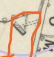
Detail from 1862 OS map showing path leading to the Malt Kiln, possibly Car Lane
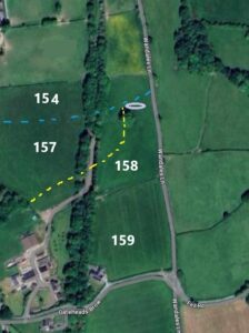
Modern aerial photograph which shows that the field border between fields 154 and 157 has also disappeared
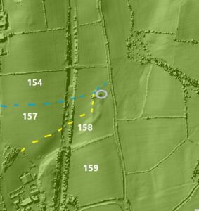
LIDAR Map showing raised ground on the site of the Malt Kiln inside the purple circle
Eighteenth Century Documentation
As noted above, the Malt Kiln has featured in numerous legal documents over the years. They offer glimpses of who owned or used the Malt Kiln. These are reviewed below.
Document – 1
The earliest record of the field and the Malt Kiln is from a document dated 2 February 1735. The parties to the contract were Nicholas Thornber of West Bradford and William Bryer of Lancaster. William Bryer provided a loan of £360 to Nicholas Thornber who used the following land as security, The Tarn and Tarn End, Little Beckside, Stubbing, Little Far Close, Great Far Close, Pess Close, Lea Close, Redhead, Hall Park, the Croft, the Cragg, Woodwell Parrock, one Brackendale on Fell close, the Three Roods, Jackson’s Lamb Parrock, Bland’s Lamb Parrock and Mawkin Acre. The Malt Kiln was in the field named Redhead.
The person drafting the deed felt it necessary to note that the land had been inherited by Nicholas from his father-in-law. The document shows that Nicholas Thornber, had previously lived in West Bradford, Yorkshire before moving to Casterton.[12] He married Elizabeth Turner in Kirkby Lonsdale in 1734 and went on to have at least two children, Anthony born in 1736 and Christopher, likely named after Elizabeth’s father Christopher Turner.
Christopher senior married Margret Briers in Kirkby Lonsdale in 1709. Their first child, Lawrence was born in Casterton in 1711. Their daughter Elizabeth arrived in 1712. There followed another four children, none of whom survived childhood. There was Anna (1714 –14), Joshua (1715 – 16), Merinah (1719 – 19), George (1721 – 1730) and Christopher (1723 – 1726). Christopher senior must have died before or soon after his daughter’s marriage to Nicholas.
When Christopher Turner senior died, some time after 1730 and before 1735, Elizabeth was still alive. With the law of inheritance at the time it seems that Lawrence had died. At this time, inheritance followed English common law, which stated the eldest son should inherit, (known as primogeniture). If the eldest son died without children, the next eldest male would inherit and so on. If there were no sons, then the estate would be divided, and all the daughters would inherit as coheiresses.
Historically, a married woman’s property, including earnings and possessions, became her husband’s upon marriage. (This remained the case until the Married Women’s Property Acts of 1870 and 1882, which granted women greater control over their property.) The estate inherited by Elizabeth therefore became the property of her husband Nicholas when they married in 1734. In 1735 it was therefore Nicholas who was named on the above indenture as the owner of the property rather than Elizabeth.
Document – 2
A few years later, on 14 January 1737, the mortgage from William Bryer was assigned to Ann Welch, a Spinster from Leck, and her brother Thomas Welch also of Leck, a gentleman with lands at Casterton.[13]
Document – 3
The following year, on 2 February 1738, the mortgage was increased from £360 to £500.[14] Thomas Welch was not mentioned on the document, only Ann. Also of note was that a witness to the document was John Cragg. He who would later buy the property including the Malt Kiln.
Document – 4
One year later there was a three-party indenture between 1) Nicholas Thornber of Casterton, a Gentleman, and Elizabeth his wife, 2) Ann Welch, a Spinster of Leck and 3) John Cragg of Casterton, a Yeoman. The date of the indenture was 24 February 1739.[15]
The deed confirms that Nicholas had previously borrowed £500 from Ann Welch and adds that he later received a further £25 from her. Later still, unpaid interest had accrued to the value of £20 pounds and 5 shillings.
As previously recorded, the property listed in the deed not only included land but also included buildings such as a house, outhouses, barns, stables, orchards, gardens, fronts, yards, backsides, crofts and folds and, pertinent to this sketch, Malt Kiln lands.
The fields, all in Casterton, referred to in the document were the same as in the 1735 document. That is Tarn, Tarns End, Little Backside, Stubbing, Little Far Close, Great Far Close, Peas Close, Lea Close, Redhead, Hall Park, The Croft, The Cragg and The Wood and Well Parrock. This deed added that these fields ‘in all containing by estimation about twenty acres be the same more or less’.
The other land mentioned in 1734 were also present in the 1739 document. i.e. a field named One Brackendale in Casterton Fell Close, a close called three Rood, one dale or parcel of ground in a close called Bland’s Lamb and one other close called Mawkin Acre. The later named fields ‘contain by estimation about three acres and a half.’
The 1739 document suggest that Nicholas had not been a successful custodian of the land that he inherited from his father-in-law. It appears that Nicholas Thornber had difficulty paying Ann Welch. It was therefore agreed that John Cragg would settle the debt in full and pay an additional £40 and fifteen shillings in return for the land on which the loans had been secured.
When the documents were signed Ann Welch wrote ‘I do hereby acknowledge that I have received of(f) the within named John Cragg the several within mentioned sums of five hundred and twenty five pounds and twenty pounds five shillings making together five hundred and forty five pounds five shillings in full discharge and satisfaction of all principal and interest due to me upon the within verified securities. As witness my hand the day and year first within written—-’ There were three witnesses who also signed the document, Thomas Welch, (Ann’s brother), John Jackson and James Farrer (?).
At the same time, Nicholas Thornber wrote ‘I do hereby acknowledge that I have received from the within named John Cragg the legal sum of forty pounds fifteen shillings being the remainder of the within mentioned sum of five hundred and eighty six pounds the purchase money or consideration for the within granted premises after payment of the within mentioned sum of five hundred and forty five pounds (note that it omitted the five shillings) due to the within named Ann Welch. As witness my hand the day and year first within written.’ Signed Nicholas Thornber with the same three witnesses.
New Owners
The new owner of the land and therefore the Malt Kiln was John Cragg, a Yeoman, born in 1700. In 1738 he married Ann Briggs, fifteen years his junior, in Kirkby Lonsdale. John’s father was also named John (1669), and his mother was Alice Priestman (1669 – 1740). Clearly the Cragg family were of some substance, as noted below, John was also able to afford to buy a significant property for £920 in October 1739.
John and Ann’s first child was Robert Cragg, born 1740, He went onto inherit most of the properties of his father. John and Ann had at least four more children (see family tree below). The third son, named John, also inherited property while the other children received bequests.
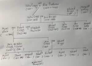
The Cragg family tree showing John Cragg (1700 – 1769) who bought the Malt Kiln and his son Robert (1740 – 1820), who inherited it
Document – 5
On 16 October 1739 there was another legal document. It seems to be a transfer of additional lands owned by Nicholas, inherited from his father-in-law which were also bought by John Cragg (1700 – 1769).[16] The consideration was £920. There is an inconsistency that I have yet to resolve. Included in the list of the fields that were being purchased in October 1739 were the fields that he seemed to have already purchased in February 1739. It may be that the February 1739 purchase was in fact a loan, although the wording in the document suggests to the contrary. Perhaps a new deal was struck later in the year when the estates were bundled together and sold as one. Whatever, the Malt Kiln was now in the possession of John Cragg.

The signatures of Nicholas Thornber and John Cragg on the October 1739 document
Nineteenth Century Documentation
Document – 6
The next document in the Kendal archives was written 65 years later in 1804. By this time John Cragg (1700 – 1769) had died, it was his eldest son Robert who was named in the manuscript. This is the earliest mention of somebody, i.e. Robert, being named as the Maltster, although clearly there were others before him.
The legal document dated 16 February 1804 referred to an earlier document from 1782. In this document, Robert Cragg had borrowed £400 from Thomas Tiffin, a gentleman from Newbrough, Yorkshire. In return, Tiffin was offered as security the same property as listed in the documents 1 – 4 detailed above.
When Thomas Tiffin died without a will around 1777, his interest in the property passed on to Mary Robinson, a widow from Kirkby Lonsdale. Mary was the only child of Thomas Tiffin. When she inherited the loan, Mary asked Robert Cragg to pay her back. He was unable to do so and therefore arranged for another party to lend him money, using the same property as security for the loan.
The new lender was Margaret Turner, a Spinster from Kirkby Lonsdale. It seems that Robert Cragg had some spare money, he repaid Mary Robinson £100 and borrowed £300 to repay the balance. I do not know whether Margaret Turner was related in anyway to Christopher Turner the earlier owner of the land.
Alongside the 1804 Indenture in the archives there is a schedule of interest payments. It details the annual payments of interest starting in February 1805. The first payment was £14 and 5 shillings. In 1807, an allowance was made for a property tax, the sum of £1 and 10 shillings which was deducted from the interest payments. This arrangement continued until February 1820.
Document – 7
A manuscript dated 14 February 1817 provides details about a mortgage to Robert Cragg, who was described as a Maltster, from John Moore, a gentleman from Whittington.[17] The sum was £500 secured on Robert Cragg’s property which the 1816 enclosure map identifies as being where Holly Bush now sits (see below).
The document records that at this time, the Malt Kiln was occupied, i.e. used, by John Carter who as noted above was Robert’s son-in-law having married his daughter Mary in 1800. The evidence also shows that the Carters were living in the house that was soon to be called Holly Bush and continued to do so for many years thereafter. This will be explored in a future sketch about Holly Bush.
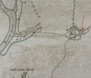
Extract of 1816 enclosure map showing ‘R Cragg’s House’ now Holly Bush. Note that the map predates the church and school [18]
Document – 8
In 1818, Robert Cragg’s will includes the following statement; ‘I give and devise to my daughter Mary Carter her heirs and assigns forever the following premises, … all that my Malt Kiln situate in Casterton aforesaid now in the occupation of John Carter and the ground and soil whereupon the said Malt Kiln stands with a right of Road to and from the same from and out of Car Lane together with eight yards of land in breadth on each side of the said Malt Kiln or as much thereof as can be got without removing any of the fences near the same with all the rights Members and appurtenances whatsoever thereunto belonging and I do order and direct that my said daughter Mary Carter her heirs and assigns shall make and forever thereafter uphold and support a fence for inclosing the same at her and [?] own expense.’[19]
As shown on the Cragg family tree above, when he wrote his will, Robert’s new wife was Elizabeth Rawlinson, who he had married in 1788. The beneficiaries of the will suggests that if Robert and his first wife Agnes Boak, had had sons, they were no longer alive. His two surviving daughters, both married, were Ann Briggs (born 1769/70) and Mary Carter (born 1779).[20]
The will shows that the Malt Kiln and fields were left to Mary Carter, the wife of John Carter who was still using the kiln as the village Maltster.
Document – 9
In 1842, a newspaper recorded details of a forthcoming auction of land associated with Bee Nest. The land listed as part of the ‘Bee Nest Estate’ included the fields previously owned by Christopher Turner i.e. the Croft, Three Rood, Lamb Parrock, Sour Flatt, Pess Close, Lea Close, Redhead, and Hall Park. It appears that Redhead, the field which contained the Malt Kiln, was now associated with the Bee Nest Farm rather than Holly Bush Farm.
The successful bidder was William Wilson Carus Wilson. He is listed the following years as the owner of the property on the tithe documents. The tenant farmer remaining Thomas Atkinson.
The Malt Kiln, despite being in the field named Redhead, now owned by Wilson, was still owned by John Carter, again highlighting the fact that the Malt Kiln was a separate asset to the field in which it was located.
Document – 10
In 1850, further land that had historically been owned by Christopher Turner was put up for auction. The auction offers the same description of the position of kiln in the field as described in the 1818 will.
‘Lot 2,
ALL THAT
MALT KILN
Situate at Casterton aforesaid, with a Right of Road to, from, out of Car Lane, together with Eight Yards of Land in breadth on each side of the said Malt Kiln, and which Malt Kiln is now in on now also in the possession of the said James Carter.’[21]
Note that James’ father John had died a few weeks earlier on 14 January 1850 aged 78. Perhaps this had prompted the sale of not only the Malt Kiln, but also Holly Bush Farm which was lot 1 in the auction.
It is not clear whether the 1850 auction referred to above actually led to a sale. The 1851 Census shows that the Carters are still living at Holly Bush. It may have been part of the sale arrangement that they could still live there for a while. After the death of his father, James Carter was now the head of the household, still unmarried, and still a Maltster, now aged 46.
Beer Houses in Rural UK in the Mid-Nineteenth Century
The beer house as a distinct institution had its origins in the early nineteenth century. Prior to the 1830s, drinking establishments in rural Britain such as the George and Dragon were typically alehouses or inns, where a variety of alcoholic beverages, including ale, spirits, and sometimes wine, were served. These establishments were subject to licensing laws that regulated their opening hours and the types of drinks they could offer.
The Beerhouse Act of 1830 marked a significant turning point. It legalised the opening of small, low-cost beer houses across the country. The goal was to encourage the consumption of beer, an often safer alternative to water, which was frequently contaminated, enabling working-class people to enjoy a drink without the higher costs associated with traditional taverns or inns. The new law allowed anyone with a modest budget and a small fee to open a beer house, leading to a dramatic increase in the number of these drinking establishments across rural England.
By 1850, thousands of beer houses such as the Carpenter’s Arms had opened, often in villages or small towns, where they became critical to the social fabric of rural communities.
The increase in the number of beer houses raised concerns about the potential social consequences of widespread drinking. The government was increasingly concerned about the social and moral impact of cheap and accessible alcohol. By the mid-nineteenth century, this growing concern led to several reforms aimed at regulating and, in some cases, curtailing the influence of alcohol on society. One such measure was the Licensing Act of 1872, which introduced more stringent controls on the opening and operation of beer houses. This was probably irrelevant for the Carpenter’s Arms, it does not appear on the 1871 Census and had probably closed sometime between 1861, when it still made an appearance on the Census of that year, being run by Joshua Hutchinson with his wife Elisabeth, and 1871.
A Beer House – a Complimentary Business
A newspaper report from 1851 shows that there was a beer house in Casterton named the Carpenter’s Arms, located opposite the George and Dragon (The Pheasant). The report described a Casterton games day organised by the Landlord as follows, ‘The Whitsuntide period has been rather barren of amusements in this neighbourhood, but Mr. Hutchinson, of the Carpenter’s Arms inn, spiritedly offered few sporting prizes for the diversion of the rural youths, and the games came off on Wednesday last. The sports commenced with the race for a hat, which was won by Horner, of Kirkby Lonsdale. Next followed a trotting match, and five smart nags started; the prize was won by Mr. Tomlinson’s “Clear the Way,” beating Mr. Wallings “General Post Office”, by half a neck, and distancing three others. The wrestling was won by Robert Dixon, of Kirkby Lonsdale, in clever style. A race for £5 a-side, between John Thornton and Wm. Smith, both of Kirkby Lonsdale, excited much merriment. Thornton is 70 years of age, but “souple as an eel,” whilst Smith has only just seen his 25th summer. Smith agreed to give Thornton a 100 yards start,- the distance [of the race] a quarter of a mile. The “old ‘un”, of course, went away with the lead, was never headed, and won cleverly by 80 yards. An assembly in the evening concluded the day’s sport, which was attended by all the “bonnie lads and lasses” of Casterton and neighbourhood, and after “tripping it on the light fantastic toe.” the company separated highly delighted with their day’s amusement.’[22]
It is notable that the winners all appeared to have come from Kirkby Lonsdale. It was quite common at this time for there to be running races which, like horse racing today, were handicapped. In this case by offering a head start rather than a weight handicap. The prize of £5 was quite something, equivalent to about £460 in 2025 terms.
James Carter had occupied this house since at least as early as 1843. The tithe record shows the beer house as property number 184 described thus ‘Carpenter’s Arms & Cottage, Garden & Outbuildings’. It was owned by ‘Bownass Richard and another Trustees of Allan Kirk’, in other words it had been part of Allan Kirk’s estate before he died and was now held in trust by Richard Bownass and other trustees. The beer house was occupied by Alice Thornborrow & Joshua Hutchinson.
In 1856 the beer house and an adjoining cottage were offered up for auction as well as the other property held in trust by Richard Bownass and others. The beer house was noted as being occupied by Joseph Hutchinson, Edward Thornborrow and James Carter.[23] Being a Maltster, James was providing malt to brew the beer that was served in the Carpenter’s Arms.
The buildings are still there today and known as Fern Cottage with the outbuilding now called Honeysuckle Barn.
Final Evidence of Malt Kiln
By 1861 James was no longer living at Holly Bush, he had moved up the road to Bee Nest Farm. He may well have bought this farm back from William Wilson Carus Wilson because it formed part of his will when he died 15 years later. Perhaps he used the sale proceeds from Holly Bush to buy back Bee Nest.
James was listed as the head of the Bee Nest household. His occupation was still recorded as Maltster and Landowner. This suggests that the Malt Kiln was still being used. Living with him was his cousin Agnes Wilkinson, as Housekeeper.
By 1871 James was again living at Bee Nest Farm, still with his housekeeper and cousin Agnes. Also living there was another James Carter, aged 13, his nephew, the son of his brother George who had died in 1871, before the census was taken. James senior was no longer referred to as a Maltster but was still a landowner.
James died in 1876, still unmarried, and was buried in Holy Trinity Graveyard. It was the end of an era. He was the last person who malted barley in Casterton in the Malt Kiln located in field called Redhead. He had followed from his father John Carter who in turn had followed his father-in-law Robert Cragg who in turn had learned the role from his father John Cragg.
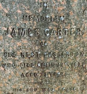
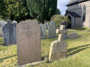
The gravestone and detail of James Carter, the last Maltster in Casterton, in Holy Trinity church graveyard[24]
Simon Drakeford
February 2025
References
- Much of this section’s content is taken from H Stopes, Malt and Malting: An Historical, Scientific, and Industrial Treatise, Brewers’ Journal Office, 1885
- Courtesy of the author
- Clunch is a soft limestone capable of being easily worked.
- Stopes, Malt and Malting, p184
- Stopes, Malt and Malting, p199
- Stopes, Malt and Malting, p186
- Stopes, Malt and Malting, p192
- Stopes, Malt and Malting, p295
- Cumbria County Archives (Kendal), WDCW/2/4/2/4
- For example, see discussion in Colin Seymour MA BA(Hons) Cert. Ed., Public and private occupation roads, The Byways & Bridleways Trust, 2015
- Courtesy of the Cumbria County Archives (Kendal), WQ-RDP-78
- Cumbria County Archives (Kendal), WDCW/2/1/3/13
- Cumbria County Archives (Kendal), WDCW/2/1/4/13
- Cumbria County Archives (Kendal), WDCW/2/1/4/14
- Cumbria County Archives (Kendal), WDCW/2/1/3/14
- Cumbria County Archives (Kendal), WDCW/2/1/4/15
- Cumbria County Archives (Kendal), WDCW/2/1/3/20
- Courtesy of the Cumbria Archive Centre (Kendal), WPR 19/14/1/1
- Cumbria County Archives (Kendal), WDCW/2/4/2/4
- The Kirkby Lonsdale Parish Registers indicate that Robert and Agnes only had two children.
- Lancaster Gazette, 2 February 1850, p4
- Kendal Mercury, 14 June 1851, p5. The phrase is familiar to day but omits the word ‘toe’ which referred to the dancer’s footwork.
- Lancaster Guardian, 16 August 1856, p1
- Courtesy of the author