

The farmer who owns the private field that the Stone Circle stands in is not keen to have visitors into the field. Please respect this and do not walk on the private land.
Introduction
As well as Casterton having a Roman road running through it, it also has a construction significantly older. Depending on which accounts you read, it is either Neolithic (around 4,300 BCE to 2,000 BCE) or Bronze Age (around 2,000 BCE to 800 BCE). The consensus suggests that it is Bronze Age.
Our circle is certainly nothing on the scale of Stonehenge, in fact significantly smaller, but an ancient stone circle none the less!
Fortunately, readily available on You Tube, is some amazing drone footage of the Stone Circle posted by Sky Cam Footage in 2018. This offers a much better view of the circle than you could ever have when stood next to it. The footage really gives a sense of the structure and layout.
Video here https://www.youtube.com/watch?v=bZjgvHcGcTE
It is also possible to view the circle from a distance from the nearby public path heading to Brownthwaite Pike. A good time to see the Stone Circle is when the sun is low in the sky or following a light sprinkling of snow when the stones and their shadows stand out more clearly.
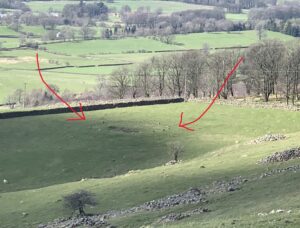
Photograph of Stone Circle taken from nearby foot path in 2023 [1]
The Stone Circle on Maps
Although it can be found on modern OS maps, the Stone Circle did not appear on the enclosure map of 1816, the tithe map of 1843, or the early OS maps, although the field itself features in all of them.
The enclosure map indicates that the 21-acre field, number 17 on the map, was owned by James Tatham. Before Casterton Fell was enclosed, the Stone Circle was in open ground.
On the tithe map the field number is 444. The records show that the field was called ‘Allotment.’ It was owned by Joseph Dawson and rented by Thomas Morphett. Field 444 was the only field in Casterton that Dawson owned or that Morphett was listed as tenant of. Neither gentleman appear in the 1841 or 1851 censuses of Casterton.
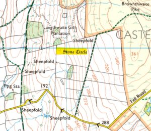
Extract of the current OS map showing the location of the Stone Circle and footpath adjacent to the field
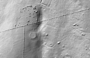
LIDAR image of the Stone Circle
Heritage Gateway
The Stone Circle is a listed monument although the listing does not include any details about it. [2] Some details are included on the Heritage Gateway website. Heritage Gateway is managed by Historic England providing access to local and national records on the historic environment.
This listing records the following details ‘Embanked stone circle of probable Bronze Age date, surviving as a structure/earthwork, although alternative interpretation as a ring cairn cannot be ruled out. No artefact discoveries can be firmly attributed to the site although claims have been made for a bronze spearhead, a flint arrowhead, and a probable Beaker, all 19th century finds.’
And adds that ‘The monument is much as described by previous authorities. It occupies a low knoll situated within a natural shelf or bench in the hillside, and commands extensive views west and south over the Lune valley. It comprises a penannular bank, circa 16m in internal diameter, with stones arranged every 2-3m around the inner face although there are ‘gaps’, presumably where stones are either missing or grassed over. There are 17 stones visible, up to circa 0.4m high… It is probably an embanked stone circle, although an interpretation as a ring cairn cannot be ruled out.’ [3]
Note that a ring cairn is defined as ‘A prehistoric ritual monument comprising a circular bank of earth or stones up to about 20 m in diameter surrounding a hollow central area.’ [4] Within the hollow central area may have been some type of ritual burial. An embanked stone circle would not have had a hollow centre.
Transactions of the Cumberland and Westmorland Antiquarian and Archaeological Society
One of the previous authorities that mentioned the Stone Circle was in a 1963 article published in the Transactions of the Cumberland and Westmorland
Antiquarian and Archaeological Society. ‘The “Druid Circle” at Casterton… is a circle of 59 ft. diameter, consisting of 20 stones, in height up to 1 ft. 7 in. Of this circle, Sir Mortimer Wheeler wrote that it “… would be dismissed at once as the remnant of a tumulus but for the fact that it is sited carefully on a levelled platform…There is also the possibility that there was a Beaker burial at the Casterton circle site, as is discussed by Miss Fell in CW2 liii, 3.’ [5]
Miss Fell’s article clearly states that the ‘Druid’s Circle’ may be Casterton’s Stone Circle. In my opinion an unlikely possibility, which was speculation based on a rather vague newspaper report from 1828 about several artefacts found about ‘21 miles from Lancaster, on the road to Richmond’. [6] Taken literally, this would place the location as Chapel le Dale.
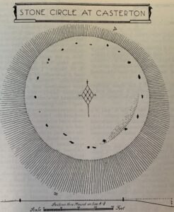
A plan of the Stone Circle [7]
A Royal Commission Inventory
The Royal Commission on Historical Monuments England which produced an inventory of the historical monuments in Westmorland records the following details ‘STONE CIRCLE and mound 350yds E. of Fellfoot Road and 200 yards S.E. of Langthwaite Gill Plantation. A slight mound roughly circular in shape with a flat top (except for a slight rampart on part of the E. side) has been formed at the end of a small spur. In the mound is a stone circle of an average diameter of 59 ft. and consisting, now, of twenty stones. Two of these stones now show only as small points through the turf. The remainder are of varying heights up to 1 ft. 7 in. There has apparently been some slight excavation against the western scarp of the mound.
About 8 yards N. of the stone circle are faint traces of a roughly circular sinking with fainter traces resembling a surrounding bank on pat of the circumference. [Clearly visible on the LIDAR image above.]
In the next field to the S. and some 200 yards S. of the stone circle is a circular sinking of some 18 yards diameter with traces of a few fallen stones suggesting a former encircling wall on its E. side.’ [8] This circular sinking is also visible on the LIDAR image below.

LIDAR image of the Stone Circle and identified by arrow the ‘circular sinking’

Winter scene showing the circular Stone Circle and the ‘circular sinking’. [11]
A Recent Observation
In more recent writings, in his book ‘Ring of Stone Circles,’ Stan L Abbott visited the circle as part of his electric bike tour to visit all the known ancient stone circles in Cumbria. He observes that ‘The county is, in terms of absolute numbers and the frequency of its circles, the most important in England.’ [9]
About Casterton circle he noted that the circle ‘is both reasonably intact and reasonably substantial, suggesting a raised embankment of about 16 metres in diameter, with seventeen stones of up to perhaps half a metre high… opinion seems divided as to whether this is an embanked stone circle or the remains of a ring cairn, though I personally err towards the former.’ [10]
Simon Drakeford
December 2024
References
- Courtesy of the author
- See https://historicengland.org.uk/listing/the-list/list-entry/1007245?section=official-list-entry . Accessed 5 December 2024
- See https://www.heritagegateway.org.uk/Gateway/Results_Single.aspx?uid=44113&resourceID=19191 . Accessed 5 December 2024
- See https://www.oxfordreference.com/display/10.1093/oi/authority.20110803100421882?rskey=ZwbFdE&result=13 . Accessed 9 December 2024
- TCWAAS 2, Vol 63, ‘Celtic Fields, farmsteads, and burial mounds in the Lune Valley‘, R.A.C. Lowndes M.A., p9
- TCWAAS 2, Vol 53, ‘A Beaker Burial on Sizergh Hill near Kendal’, Clare Fell F.S.A., p3
- Royal Commission on Historical Monuments England, An Inventory of the Historical Monuments in Westmorland, 1936, p67
- Royal Commission, An Inventory, pp66-7
- Stan L Abbott, Ring of Stone Circles – Exploring Neolithic Cumbria, 2022, p1
- Abbott, Ring of Stone Circles, p38
- Courtesy of Ken Humphris
Thank You