

Introduction
One of the most ancient documented industrial buildings in Casterton is a watermill. There is ample evidence of Casterton’s mill in old documents, local field names, archive newspapers, maps, and books. This Sketch draws together this evidence to produce an almost continuous timeline of the mill from the 13th to 19th centuries.
Through a chance find in a 19th century book, it is now possible to identify exactly where the mill was located. Sadly, no remnants of the mill remain, either on the ground or in the water. However, as described below, there is some photographic evidence!
A Brief History of Medieval Watermills in the North of England
Watermills played a crucial role in the economic and social development of medieval Britain, particularly in the northern regions. These structures harnessed the power of water to grind grain, saw wood, and perform other early industrial tasks.
The earliest use of watermills in Britain dates to the Roman period, with archaeological evidence suggesting their presence as early as the first century AD. However, it was during the medieval period (from the fifth to the fifteenth century), that watermills became a widespread and integral part of everyday life.
Northern England, with its abundant rivers and streams, provided an ideal environment for the establishment of watermills. By the late Anglo-Saxon period (10th–11th centuries), watermills had become increasingly common, as recorded in documents such as the Domesday Book of 1086, which lists over 5,000 mills across England, but not in Casterton.
The Norman Conquest of 1066 accelerated the spread of watermills due to the introduction of feudal land ownership structures. Lords and monasteries, who controlled vast lands, invested in the construction of watermills to enhance agricultural production and generate revenue through milling fees. Peasants and serfs were often required to use the Lord’s mill, leading to the establishment of manorial mills that formed the backbone of rural economies. From the records, it appears that Casterton’s mill was a manorial mill.
Throughout the medieval period, the technology of watermills improved significantly. Early watermills typically employed simple horizontal wheels, but by the 12th century, vertical wheels became more common. These vertical wheels could be divided into two main types: ‘overshot’ and ‘undershot’.
Overshot wheels used gravity, with water flowing from above to turn the wheel. They were particularly effective in hilly areas where water could be channelled from higher elevations.
Undershot wheels used the kinetic energy of a flowing river or stream to turn the wheel from below. They were more suitable for flatter landscapes, such as the lowland areas of Yorkshire and Lancashire.

Example of an old watermill in woods from an old print (NOT Casterton’s)
The introduction of gears and cams in the later medieval period allowed watermills to perform more specialised functions. Some mills were adapted for fulling wool, a crucial step in textile production, while others powered forge hammers for ironworking. There is written evidence that Casterton’s mill was, for some time at least, a fulling mill.
By mechanising the grain milling process, watermills significantly reduced the time and labour required to produce flour. This allowed farmers to focus on other agricultural activities and contributed to population growth. There is evidence that the mill at Casterton was used to grind corn.
Early Records of Casterton Mill
The earliest evidence of a mill existing in Casterton, and also evidence of the village’s earliest economic activity, is found in the papers recording an inquisition after the death of Walter de Lindsay in 1271. This document reviewed the assets that he owned. In the mid 13th century, Walter de Lindsay had significant land holdings in the manor of Casterton, inherited from his father William(1).
The inquest, held in 1272, noted that that Walter held a mill ‘belonging to Casterton, yearly worth 75s., and he received the rent of a certain mill dam upon Lone [the Lune] belonging to Casterton – viz, 4s.’[1] Walter’s son, another William(2), inherited the lands from his father when he died in 1282.
William(2) and the mill are mentioned in the Calendar of Close Rolls related to King Edward I. The Close Rolls were a central record of all letters issued by the Royal Chancery in the name of the Crown.
The relevant record, dated 20 May 1285, shows that Roger, the son of Thomas de la Wodhalle, confirmed that William(2), the ‘son of Walter de Lyndeseye’ has acknowledged at the exchequer that he owed Roger £120 in consideration for his right in the Manor of Whittington and in the mill of Casterton, and that it had been released to his daughter and heiress Christiana and her husband Ingeram de Gynes.[2]
The next historical mention of the mill was when Christiana, (Walter’s granddaughter), died in 1334. At the time of her death, she possessed a water corn mill in the manor of Casterton worth £3 6s. 8d.[3]
15th Century Records
The next mention of Casterton mill is 120 years later. In 1454 there is a record of a fulling mill which had been formerly let for 6s. 8d. per annum. It was unoccupied at this time and belonged to the Lord of the Manor.[4]
Fulling mills and fulling were part of the woollen cloth making process. It involved cleaning and milling woven cloth to produce a material that is thicker and denser, and therefore warmer and often water repellent.
In a later record, from 1492, a Christopher Symson paid 4d rent ‘for licence of putting a grindstone in Casterton Beck, to be turned by the water thereof, for the fulling mill.’[5]
A 16th Century Record
In the book Place Names of Westmorland, there is a reference to a mill in Casterton in a 16th century document. The book references a record held in the Public Records Office at Kew.[6] The record, from 1577, describes the mill at Casterton as ‘one water corne mylne called Gyll Mylne’. So at this time, the mill was for grinding corn and was called Gill Mill.
17th Century Records
There is a gap of about 60 years before Casterton mill is again mentioned in the historical record. The fact that there is a gap in the records in no way suggests that there was no mill. As noted above, a mill was a valuable asset to any community. The fact that it was held by the Lord of the Manor in 1454, was working in 1577, and was still part of the Manor in 1637 (see below) suggests that it was in continuous use.
When George Stockdale died in 1637, he owned ‘one water grain mill’ in Casterton. The record adds that the mill was held by the King as part of his manor of ‘Eastgreenewich’ [East Greenwich] in Kent in ‘free socage[7] and by yearly rent of 20s. and is worth yearly clear 10s,’[8]
After George’s death, his property, including the mill, was inherited by his daughter Rebecca Stockdale, his sole heir. Rebecca married Robert Lowther of Ingleton.
The historical documentation I have located now changes from being references in the scholarly volumes of the records of the Kendal Barony, to documents held at the Kendal Archives.
The Wilson Family
A document in the Kendal Archives shows that in June 1639 Robert Lowther, the husband of Rebecca, sold the house named Beckside (later called Casterton Hall) including the corn mill and other property, to Thomas Wilson (1592 – 1656) of ‘Heversham Haule’ (Heversham Hall) for £1,540.[9]
As can be seen in the family tree below, this was when the ancestors of the Reverend William Carus Wilson became connected with Casterton.
The archive document is lengthy and extremely hard to read, but it confirms that, as well as there being a mill, there was other property included with the house called Beckside and fields with names recognisable today, such as Millbank, Gildhead, Great Kirfitt and Little Kirfitt.[10]
When Thomas Wilson died in 1656, his son Edward (1618 – 1707) of Dallam Tower and Casterton Hall, inherited Beckside, by now called Casterton Hall and the watermill.
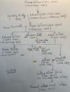
Partial family tree of Wilson / Carus family showing inheritance of Casterton mill
Further details about Casterton mill can be found in another of the Kendal Archive’s documents. The record, dated 11 December 1685, concerned a marriage settlement of the child of Edward (1618 – 1707) and his second wife Dorothy (nee Kirkby).[11] Their child was named Roger Wilson (1662 – 1690) and his fiancée was Miss Jane Foxcroft (1662 – post 1713) of Holme House, Whittington.
Jane was the daughter and heir of John Foxcroft, a lawyer, who died around 1666 and left Holme House and his lands to Jane.[12] Roger’s father Edward (1618 – 1707) was still alive when his son married.
As well as mentioning Casterton mill, other properties mentioned in the 1685 document included Widdall House in Wensleydale, the Tythes of Tunstall, the Troam under Gildhead in Casterton, and Casterton Hall. Again, it is difficult to decipher the document, but it appears to be a prenuptial arrangement specifying what should happen to their property if Jane predeceased Roger and vice versa.
One year later, a document shows that Edward Wilson (1618 – 1707) was summonsed by warrant to appear at the King’s Majesties audit ‘to be holden at ye Kings Arms in Kendal… on ninth day of October’ [1686], concerning monies due to the king for Casterton mill.[13] This was presumably in connection with unpaid customary rent that he owed the crown.
In 1721, there is a record of another Edward Wilson (1687 – 1726) leasing Casterton Hall, its water corn mill and 130 acres of land and some part of Dallam Tower to Edward Bannister of the Inner Temple of London for a peppercorn rent of five shillings for one year.[14] The document doesn’t mention why the rent was so low.
This Edward was the eldest son of Jane Foxcroft and Roger Wilson (1662 – 1690), named after Roger’s father. Sadly, Edward (1687 – 1726) died without any heirs and so his younger brother, another Roger (1690 – 1755) inherited Casterton Hall, its lands, and the mill.
It was therefore Roger who advertised the rental of Casterton Hall in the Kendal Weekly Mercury in 1739. The advertisement read,
‘To be LETT for a Term
CASTERTON HALL, near Kirkby Lonsdale, with about a hundred Acres of Land, a Water Corn Mill, and all other Conveniences belonging to the same, —– Any Person that has a mind to take the same may apply to Roger Wilson Esq; of Casterton, aforesaid’[15]
Barbon or Casterton?
Roger (1690 – 1755) had a son also named Roger (1727 – 1769). This Roger also appears as a mill owner in historical records. However, the narrative within the record suggests that the mill was in Barbon.
The document dated 1762, records that Ann Wilson on behalf of her brother Roger Wilson (1727 – 1769) of Casterton Hall rented a mill to Thomas Bland of Casterton, a miller, for the sum of £12 and 12 shillings.[16] On the face of it, this would appear to be the Casterton mill, especially as the document also mentions that he rented a drying kiln. As noted below, there is a large kiln close to the site of Casterton mill. However, the mill is named as Beckfoot Mill.
One of the conditions of renting it was for Miller Bland to repair and maintain the mill and kiln and the wear of Barbon Beck. There was a Low Beckfoot Mill in Low Beck, Barbon near to where Barbon Beck joins the Lune. It is possible to walk from one mill to the other using footpaths across the fields and lanes, a distance of about 1 1/2 miles.
Renting Casterton Mill
The next record in the Kendal Archives referencing the mill is a series of receipts dating from 1792 to 1807 regarding payment of rent for the mill.[17] In the example illustrated below, a payment of £1 was made by William Wilson Carus on 17 October 1792 regarding rent for the mill. A sum of 4 shillings was deducted from the payment for property tax, and, what appears to be an administrative charge of 6 pence for the acquittance of the receipt.
The payment was received by Thomas Atkinson on behalf of the Reverend Oliver Marton (1721 – 1794). The rent’s due date was Michaelmas which is the feast of Saint Michael the Archangel celebrated on 29 September. Payments were made annually.
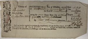
Example of a receipt for rental payment for Casterton mill in 1793[18]
This flow of money seems to suggest that it was William Wilson Carus who was renting the mill from the Reverend Oliver Marton. Oliver was the grandson of Jane Foxcroft and Roger Wilson (1662 – 1690). Perhaps Oliver had inherited the mill, via his mother Jane Wilson, or had acquired the mill. William Wilson Carus was the great grandson of Jane and Roger and therefore a relative of Oliver (first cousin, once removed – see family tree below).

Tree showing the relationship between the Rev. Oliver Marton and William Wilson Carus
Later Rent Receipts
After 1792, the payee listed on the rent receipt was named as William Wilson Carus Wilson. This is the same person as William Wilson Carus. What had changed was that he was required to add the surname Wilson to his name when he inherited Casterton Hall in 1793.[19]
The later receipts also reflect the death of the Reverend Oliver Marton in 1794. For example, the 1797 receipt shows that the paid monies were for the benefit of the late ‘Rev’d Ol’ Marton’.
Location of the Mill by Reference to Old Maps
The location of the mill is clearly marked on a map drawn up around 1800. The mill is found on Casterton Beck, or as it was called on the 1862 OS Map Mill Gill. The field above the mill was named Mill Bank on the 1800 map but Mill Hill on the 1862 OS Map.
On the 1848 tithe map the field called Mill Hill, number 240 on the tithe map, is named Conishead Hill & Stubbing and recorded as belonging to William Wilson Carus Wilson. Plot number 235 on the tithe map, through which the beck runs, is named Mill Gill Wood. The mill does not appear on the tithe map.
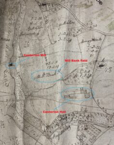
Extract of Estate Map C1800 by John Todd showing the location of the mill [20]

Extract of the 1816 Enclosure Map showing the location of the mill
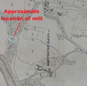
Extract of 1848 the tithe map showing the approximate location of the mill

Extract of 1862 OS Map showing the location of the mill / bath house
Victorians Visiting Casterton Woods
Casterton Woods were mentioned in a guide book published in 1885.[21] The guide book mentions a building in the woods, ‘After proceeding a little way down, [past] the Servants’ School [now Bronte House] will be observed on the right, and still further down, a ruinous building, which has formerly been used as a bath. Close to this is a picturesque Alpine bridge… Just below the bridge is a pretty cascade, one of a series that enliven with their music the charming scene around, of winding walks, gigantic ferns, gay wildflowers and luxuriant trees and shrubs.’

Casterton’s ‘Alpine’ Bridge[22]
A book written in 1892 by H. Speight, describes his visit to Casterton in 1891 and adds more detail.[23] He writes ‘there is a most beautiful walk through Casterton Woods… From the gardener’s cottage [Paries House is now on the site of the old gardener’s cottage] here a steep path descends, in a minute or two, to a picturesque wooden bridge, spanning the leafy chasm which has been formed in the red rock by the abrasion of the quick descending stream… Close to the old bridge, just mentioned, there was once, we are told, an old corn-mill, and the secluded ravine in which it was called Mill Gill. The building was afterwards converted into a private bath-house, but is now abandoned, and in ruins.’[24]
Unfortunately, there is no mention of who used the bath house. Was it used recreationally by the inhabitants of Casterton Hall, or by local Castertonians who may have welcomed the opportunity to take a private bath, albeit in a cold running stream of water fresh from the subterranean depths under Casterton Fell.
An Early Photograph
Fortunately, a photograph was taken of the area C1860, some 30 years before H. Speight visited. It shows the ‘Alpine’ bridge and the bath house, formerly the corn mill.
The source of this photograph is unknown, but it looks to be a Stereoscopic ‘3 dimensional’ photograph. This type of photograph became a worldwide craze after the Great Exhibition of 1851. Cheap viewers and mass-produced stereographs brought startlingly vivid images within reach of a mass audience, on a projector called a Magic Lantern.
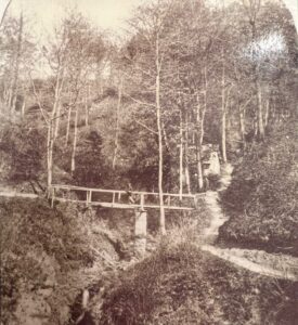
C1860 photograph showing the bath house on Casterton Beck, previously the mill, with detail below
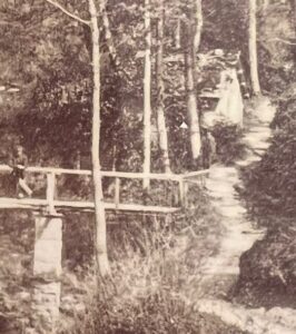
Detail of C1860 photograph showing the bath house on Casterton Beck, previously the mill
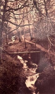
A 1920 postcard showing the view upstream with the cascade below the bridge after the bath house had been removed but with footpath still extant[25]
Today
Walking alongside the beck today, there is no evidence of any remains of the bath house / mill either on the bank or in the water. Looking at the C1860 photograph, the bath house was still standing with walls and a roof but in the subsequent 30 years it fell into significant disrepair.
What is clear from the terrain today is that the sides of the beck have fallen away. The footings of the footbridge, still viewable, are significantly below the bank where they were in the photographs above. It would be very difficult to access the bridge were it still in place today.
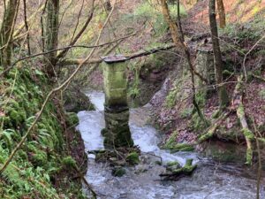
Photo of the footings of footbridge looking downstream – 2024, courtesy of the author

Photo of the footings of footbridge from above, illustrating the extent to which the footpath has fallen away – 2024, courtesy of the author
Simon Drakeford
April 2025
References
- Lancashire Inquests, Extents and Feudal Aids A.D.1205-1307. Ed. Wm. Farrer (The Record Society 1903), p237
- Public Record Office prepared under the superintendence of the Deputy Keeper of the Records, Calendar of the Close Rolls: Edward I – A.D. 1279 – 1288, 1902, p359
- William Farrer and John F. Curwen, Records relating to the Barony of Kendale, Vol. II, 1924, p330
- Rec. Kend. II, pp332 – 333
- Joseph Nicolson and Richard Burn, The History and Antiquities of the Counties of Westmorland and Cumberland, Volume 1, J W. Strahan, 1777, p249
- A. H. Smith (Ed.), The Place-Names of Westmorland – Part 1, 1967, p29 referencing ‘Depositions taken by commission: E 134.’, Reference: PRO 57/6300
- Socage is a tenure of land by agricultural service fixed in amount and kind or by payment of money rent only and not burdened with any military service.
- Rec. Kend. II, p338.
- Cumbria County Archives (Kendal), WDCW/2/1/3/4
- Note that Kirfitt is spelled with two ‘t’s in this document.
- Cumbria County Archives (Kendal), WDCW/2/8/3/14
- Colonel W. H. Chippindall, A History of Whittington, Chetham Society, 1938, p25
- Cumbria County Archives (Kendal), WDCW/1/5/1
- Cumbria County Archives (Kendal), WDCW/2/1/1/12
- Kendal Weekly Mercury, 17 November 1739, p4
- Cumbria County Archives (Kendal), WDCW/2/1/8/28
- Cumbria County Archives (Kendal), WDCW/1/6/2
- Courtesy of Cumbria County Archives (Kendal)
- When Roger Wilson died in 1755, he left his estate to his eldest son, also named Roger. When Roger died in 1769 with no surviving issue, his sister Anne Wilson (1728 – 1790) inherited the estate. She later married the Reverend Marwood Place, vicar of Kirkby Lonsdale in 1771. When Anne died in 1790, the estate passed onto her sister Elizabeth’s son William Wilson Carus. As a condition of inheriting Casterton Hall, when his mother died in 1793, William was obliged to add the Wilson surname to his own name, thereby keeping the Wilson surname connected to Casterton Hall.
- Courtesy of Cumbria County Archives (Kendal), WDCW/19
- Thos. Johnson, A Pictorial Handbook to the Valley of the Lune and Gossiping Guide to Morecambe and District, 1885, pp30 – 31
- Johnson, Handbook to the Valley of the Lune, p30
- H. Speight, The Craven and North-West Yorkshire Highlands: Being a Complete Account of the History, Scenery, and Antiquities of That Romantic District, 1892
- Speight, The Craven and North-West Yorkshire Highlands, pp290 – 91
- Courtesy the author