


Enclosure walls on the slopes of Brownthwaite[1]
Introducing the Author
Following on from the first ‘Guest’ Sketch written by Jean Hamlett about the mysterious visitors to the Casterton Hotel in the Second World War, presented below is a second ‘Guest’ Sketch. This one was first written a few years ago by Claire Wildsmith and has been lightly updated for this Sketch.
Claire has lived in Casterton since 2005, moving there from Lancaster where she had lived for 30 years. In 2003 she gained a Ph.D. from Lancaster University on Ruskin’s art criticism. She also has an M.A. in English Literature, and in 1998 she organised an exhibition to celebrate the opening of the Ruskin Library at Lancaster.
She lives at Casterton Hall, built by William Wilson Carus Wilson in 1796, and whose son, Rev. Wilson Carus Wilson, founded Casterton School and built Casterton Church.
She became interested in the history of Casterton and enrolled in a Local History course at Lancaster University, gaining a Diploma in 2008. Part of her research included parliamentary enclosure and the way in which it affected Casterton. This forms the basis of the following Sketch.
In 2009 she put her academic training to good use when she volunteered to write a history of Casterton Women’s Institute to celebrate the ninetieth anniversary of the founding of this august body.[2]
Introducing the Topic
This second ‘Guest’ Sketch provides a fascinating insight to a contentious period in British history as experienced in Casterton.
A frequent characterisation of the effect of the enclosure of common land was that by using Acts of Parliament, big land owners were able to take control of the land that had previously been farmed by the local population, ‘the peasants’ or ‘cottagers’, in an open field system. The general situation was more nuanced, different areas of England experienced the enclosure of their land in different ways.
Ian Whyte observed that a high proportion of farmers in Cumberland and Westmorland were customary tenants whose rights to a share of enclosed land seem to have been widely acknowledged by manorial Lords.[3]
Certainly William Carus Wilson thought so. Speaking to a House of Lords Select Committee in 1844 he noted that his direct experience of Casterton Fell was that ‘I should state that I do not know a case in which any poor person has been the least aggrieved, nor have I heard of any case in which a poor person has expressed any feeling of dissatisfaction at land being inclosed. I believe their rights have not been injured in any way, but quite the contrary; because the advantage of the poor, I believe, is manifest, not only while the inclosure of the common is going forward in the way of walling and draining and clearing the stones off, which is often a very essential though a very expensive matter, but afterwards, in carrying on the improvement in planting, and increasing the walling by the process of planting. My father and I have done that to a great extent on Casterton Fell and in other places, and, of course, planting and keeping up the trees and other things has occasioned a great deal of work to the poor people, and has been of the greatest service: indeed, I do not know what would have become of the poor in Kirkby Lonsdale or the neighbourhood if it had not been for the recent inclosures.’[4]
The new system of enclosed land and larger farms did bring some advantages. Less land was wasted and it was possible to improve the efficiency of farming, enabling the land to not only provide for local needs, as it had mostly done before, but also to export surplus produce to the newly growing cities using the improving transport networks of the nineteenth century.
As described below, some of Casterton’s land was enclosed. New fields were laid out, new roads were added, and the ‘common’ land was eventually re-allocated to different farmers and Lords. I am delighted to have the opportunity to include Claire’s history of the enclosure awards as it affected Casterton as a ‘Guest Sketch’. It is thoroughly researched and offers great insight about how the lay of the land around us changed in the early nineteenth century.
Here it is…
Before the Enclosure
The straight stone walls which divide the undulating slopes of Brownthwaite and Casterton Fell are a reminder of the way in which this land, formerly common grazing, was shared out between local landowners following the Enclosure Award of 1816.

Pre dating the Enclosure, this 1770 map of Westmorland by Thomas Jeffreys, describes the hilly area used for grazing sheep as ‘Casterton Fell’ rather than Brownthwaite.
This original common land was strictly controlled by the manor court. Angus Winchester observed that ‘common rights remained central to the exploitation of the hills throughout the early-modern period, and the key institution in regulating these was the manor court, which made byelaws to govern the exploitation of common land.’[5] Rules were set in place to make sure it was only used by those tenant farmers in Casterton who had the right of grazing and that the grass was maintained in good condition. Winchester writes ‘only tenants of the manor could exercise common rights on the manor’s wastes.’ He continues ‘the common right of turbary, giving tenants the right both to cut peat for fuel and to strip turf for repairing hedge banks and for roofing, could only be exercised in respect of houses within the manor. The same principle governed the exercise of that cluster of other rights … and including the right to take bracken, gorse, heather, rushes and other vegetation for use on the farm.’[6]
After the Enclosure
Today, as the aerial photograph below shows, the slopes of Casterton Fell are divided by straight stone walls which divide up the land.
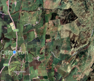
Aerial photograph 1. showing the straight lines of Enclosure walls to the north of Fell Road[7]
These straight lines are even more striking in the photograph below.
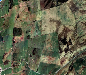
Aerial Photograph 2, showing in closer detail, the dead straight Enclosure walls to the north of Fell Road
Enclosure of Casterton Common
So how did the Casterton Enclosure Act come about, who were the powers who initiated it, and why did they think it was a good idea?
Central to the pastoral economy of upland Cumbria was access to common grazing enabled by the system of landholding known as customary tenure or tenant right, which gave tenant farmers access to common grazing and a range of common use-rights. These additional benefits included digging peat for fuel and cutting bracken for animal bedding.
For cenuries, sheep belonging to Casterton tenant farmers had grazed on Casterton Fell and the slopes of Brownthwaite on common land known as ‘sheep walks’. These precious resources were strictly controlled by the manor courts. To prevent overgrazing, only the number of sheep which could be supported within the manor during the winter could be grazed on the common in summer. The practice of grazing sheep out of the manor during the winter was outlawed by the manor court as it gave wealthier farmers an unfair advantage. Those who broke the rules were fined by the manor court, as in the examples below:
1656 – We fine Mr. Henry Wilson of Underley for wintring sheepe out of the tenement and bringing them to summer upon the Common against pain 3s. 4d.’[8]
1668 – ‘Thomas Fawcett wintering sheep out of our liberties and bringing them to the coman in summer 3s. 4d.’[9]
Those who grazed illegal numbers of sheep on the common could expect not only fines, but an angry reaction from other farmers. In 1694, four people from Casterton were fined for ‘driving away 200 sheep of one John Garnett’, whose flock grazed ‘on an ancient pasture for sheep, called Sheepheise in Easgill, on the east side of Casterton Fell’.[10]
As the market for meat expanded during the eighteenth century, farmers saw the benefits of increasing the size of their flocks, and this kind of aggressive behaviour continued. Almost 150 years later, the monopolisation of common grazing, known as ‘dogging off’, was put forward as the principal motive for the Enclosure of Casterton by the Rev. William Wilson Carus Wilson when he gave evidence to the Parliamentary Select Committee on Enclosure in 1844.
He claimed that a farmer who lived near the Fell had ‘almost monopolized the herbage, being in the constant habit of dogging off other people’s sheep’, and, in order to gain ‘complete control of the Fell’, he had acquired farms on both sides of the fell, thus preventing the ‘tenants of the landowners in general getting scarcely any benefit from the pasturage’.[11] Also, while land was held in common, the necessary improvements, such as fertilising, which would enable more sheep to be grazed, were not possible.
Enclosure Act of Parliament – 1812
It was the Rev. Carus Wilson’s father, William Wilson Carus Wilson of Casterton Hall, together with the lord of the manor, the Earl of Lonsdale, and local landowners Daniel Wilson, Joseph Gibson of Whelprigg, and James Harrison of Lowfields who decided that Enclosure would solve these problems. They obtained a private Act of Parliament in 1812 allowing them to enclose ‘the said Common and Waste grounds, and Moors and Heaths’.
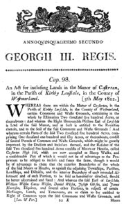
Front page of the 1812 Act of Parliament for Inclosing the Lands of Casterton[12]
Funds to meet the expenses of the Act were raised by auctioning some of the land ‘for the best price that could be gotten’. Gale Garth Farm was bought by Arthur Robinson of Barbon Fell House for £2,235.[13] Joseph Gibson bought 1,325 acres of Casterton Fell for £3,005.[14]
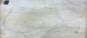
Extract from the Enclosure Map showing the 1325 Acres of Casterton Fell bought by Joseph Gibson[15]
Bull Pot Farm was created from 937 of the acres bought by Joseph Gibson.[16] It is interesting to note the role played by Barbon farmers in pushing for Enclosure and acquiring more land by doing so.
The Final Enclosure Award Document – 1816
Since the Enclosure Award was not finally drawn up until almost four years after the Act, Casterton farmers missed the opportunity of exploiting the high prices during the Napoleonic war period.
The Enclosure Award was read to interested parties on 2 January 1816 at ‘the house of Mr. James Roper (then The Rose and Crown Inn, now the Royal Hotel), Innkeeper, Kirkby Lonsdale at 11 o’clock in the morning’.[17] It consisted of schedules showing the names of the owners and the extent of their allotments, together with a large map, parts of which are reproduced above and below.

This map show the newly created allotments, easily recognised by their geometric precision, recording the names of the owners. The roads and field boundaries largely remain the same today, compare this map with aerial photograph 2 above[18]
The creation of these allotments required the building of some new roads, whose width and position were specified by the award. Public carriage roads were to be 30 feet wide while other access roads such as Fell Foot Road, Middle Road, Great Brownthwaite Moss Road, Peat Road, Bull Pot Road, were to be 18 feet wide. These were to be kept in repair by their various owners in proportion to their land holding.[19]
Turbary or Peat Digging
Before Enclosure tenants had the right to dig peat from the common. After Enclosure a public turbary was created close to the summit of Brownthwaite. Access was from Great Brownthwaite Moss Road, or from Fell Foot Road, opposite Langthwaite Lane End.
In his statement to the 1844 Select Committee on Inclosures, the Reverend Carus Wilson stated that the poor of the village had never dug for peat, the location being too distant from where they needed to use it. Furthermore, the road, built at the time of the Enclosure was too steep for easy access.[20]

Extract from the Enclosure Map showing the 1325 Acres of Casterton Fell bought by Joseph Gibson and the Peat / Turbary area[21]
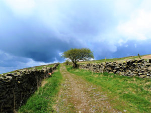
Great Brownthwaite road giving access to the turbary and newly created fields on Brownthwaite[22]

The same road looking down towards Bull Pot Road
Bull Pot Quarry
A quarry was set up at Bull Pot to meet the need for the large amount of stone required to build walls separating the allotments. The road, now known as Bull Pot Road, was marked on the Enclosure Award map as Casterton Fell Road; it was to start ‘at Fell Gate near James Dodgsons’.[23]

Bull Pot Road just above Fell Gate Farm
It provided access to both the quarry at Bull Pot and the turbary noted above on Brownthwaite via Brownthwaite Moss Road.
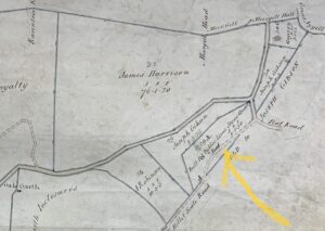
Extract from the Enclosure Map showing Bull Pot Public Lime Stone Quarry, note also Gale Garth Farm bottom left [24]

Fell Foot Road just above Fellgate Farm
This road leading north, formerly a drove road, was improved as part of the Enclosure Award.
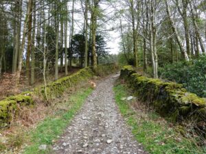
Fell Foot Road
This is the other end of Fell Foot Road close to Whelprigg, owned at the time by Joseph Gibson. The main road near here was also created at Enclosure and was to begin at ‘Bell Gate near William Dodgson’s’ and lead ‘in a northerly direction over the west side or end of the Low Fell to Grove Gill – Dent road’.[25]
Common Woodland
Besides the areas of common grazing land on Brownthwaite and Casterton Fell, there were also two areas of common woodland, shown on the maps below, included in the Enclosure Award.
The first area begins on the sloping land close to Devil’s Bridge near what is now Wood Close Caravan site and extends as far as Kirfit Hall.
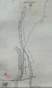
Extract of Tithe Map showing first wooded area referred to above[26]
A second Enclosed wooded area continues along the Lune to the boundary with Barbon, and for a short distance up both sides of Casterton Beck.

Extract of Enclosure Map showing the second area[27]
This woodland was traditionally a source of wood for the tenants of the manor to make fences and known as ‘Hedgbote’. The lion’s share of this area, including Gildert Woods, was acquired by William Wilson Carus Wilson, most of it adjoining land he already owned, while James Harrison purchased six acres to the north of Casterton, close to his land at Lowfields, Barbon.
Effects of Enclosure
Following Enclosure, the power once held by the manor court was superseded by the ‘rules and regulations’ to be drawn up by ‘the owners of the Estates within the Manor of Casterton’.
Lord Lonsdale, who was heavily involved, not only in the Enclosure of Casterton, but also that of many other surrounding towns and villages, profited from the £5,000 paid for land purchased by Gibson and Robinson.
The Carus Wilson family benefitted from the reorganisation and consolidation of their landholdings. As the Reverend Carus Wilson explained to a parliamentary enquiry many years later, Enclosure meant that land could now be improved by draining and liming. Previously, customary tenure made it less attractive to carry out expensive improvements, at the same time preventing landlords from raising rents. Also, if some tenants were getting little benefit from the grazing, they may well jib at paying their rent.
He told the Select Committee in July 1844 that:
‘My father had between 400 and 500 acres of this inclosure [sic] allotted him, and it remained in that state for several years, producing a rent of only £33 per year. A few years ago, he divided the high part from the lower, left the higher part for shooting purposes and black-faced sheep, and the lower has been limed … we can fat cattle for the market on the part that is limed’.[28]
Before carrying out liming, the stones had to be cleared, some was used to build the straight walls which can still be seen. In economic terms, Enclosure provided employment for local labour, while increasing the profitability of the land, rents rising from 2s. an acre to 20s. per acre for the land improved by liming at a cost of 50s. an acre. It is probable that the lime kiln and small quarry in the woods near the stone bridge over Casterton Beck were created to carry out these improvements.
Whereas formerly there had been a notion of equality between the tenants of the manor, whose common use-rights were regulated by a jury drawn from their number, Enclosure meant that the control of public quarries and turbaries passed to a small group of powerful individuals. According to the Enclosure award, the ‘rules and regulations’ governing the use of these resources were to be drawn up by ‘the owners of the Estates within the Manor of Casterton aforesaid called Casterton New Hall, Lowfields and Whelprigg’.[29] In other words by William William Carus Wilson, James Harrison and Joseph Gibson, respectively. James Harrison and Joseph Gibson were both from yeoman families whose main estates were in Barbon. Harrison’s main estate was Lowfields, on the border between Barbon and Casterton, where he also owned Folly Farm, adjacent to Lowfields, as well as a colliery on Casterton Fell.
According to Carus Wilson, Enclosure ‘occasioned a great deal of work to the poor people’, such as employment in the construction of walls and drainage ditches.[30] His equation of ‘poor people’ with labourers is evidence of the paternalistic attitude characteristic of Victorian society. He was proud of the fact that his family employed ‘a great many labourers in Casterton’, none of whom were paid ‘less that 12s a week’, and who were also provided with ‘gardens and cottage rent-free’ and milk ‘gratuitously’.[31]
It is notable that the Enclosure of Casterton not only benefitted Lord Lonsdale and the Carus Wilson family, but also landowners whose estates were in the neighbouring manor of Barbon.
Apparently, according to historian Ian Whyte, the reason for this was the fact that the Enclosure of Barbon Fell was delayed by boundary disputes, so these landowners turned their eyes toward Casterton Fell instead.[32] But whether owning land in Casterton or Barbon, it was these wealthy men who negotiated for Enclosure, and who were by far the greatest beneficiaries of the award.
Claire Wildsmith
March 2024
Reference
[1] All colour photos courtesy of Claire Wildsmith unless otherwise stated
[2] Claire Wildsmith, Casterton Women’s Institute – the First Fifty Years, 1919 – 1969, 2009, Privately Printed
[3] Ian Whyte, Transforming Fell and Valley: Landscape and Parliamentary Enclosure in North West England, Lancaster: Centre for North West Regional Studies, 2003, p91
[4] Report From the House of Lords Select Committee on Commons Inclosure Vol XX, 1845, p130, para 1643
[5] Angus J.L. Winchester, The Harvest of the Hills: Rural Life in Northern England and the Scottish Borders, 1400-1700, Edinburgh University Press, 2000, p32
[6] Winchester, Harvest of the Hills, p33
[7] Sourced from Bing.com/maps
[8] Cumbria County Archives (Kendal), WDCW
[9] Cumbria County Archives (Kendal), WDCW
[10] John F. Curwen (Ed.), Records Relating to the Barony of Kendale: Vol 3, , Titus Wilson and Son, 1926, p292-93
[11] Report From the House of Lords Select Committee on Commons Inclosure Vol XX, 1845, p124, para 1543
[12] 1812, Inclosing Lands in the Manor of Casterton, Cap 98
[13] Cumbria County Archives (Kendal), WD/Whelp/8/7, ‘Proposals for selling by auction, 21 October 1812’
[14] Cumbria County Archives (Kendal), WD/Whelp 11 Box 1
[15] Courtesy of Cumbria County Archives (Kendal), WQ/RI/14 Inclosure Award: Casterton Inclosure Award. Act: 1812 1816
[16] Courtesy of Cumbria County Archives (Kendal), WD/WHELP 11 Box 1
[17] Westmorland Advertiser and Kendal Chronicle, 6 January 1816, p2
[18] Cumbria County Archives (Kendal), WPR 19/14/1/1 Casterton Inclosure award 1816
[19] Details of the work to be done were reported in local newspapers. For example see Westmorland Advertiser and Kendal Chronicle, 28 May 1814, p1
[20] Select Committee on Commons Inclosure, p129, para 1623
[21] Courtesy of Cumbria County Archives (Kendal), WQ/RI/14 Inclosure Award: Casterton Inclosure Award. Act: 1812 1816
[22] This and other colour photographs courtesy of the author
[23] Courtesy of Cumbria County Archives (Kendal), WD/WHELP 11 Box 1
[24] Courtesy of Cumbria County Archives (Kendal), WQ/RI/14 Inclosure Award: Casterton Inclosure Award. Act: 1812 1816
[25] Courtesy of Cumbria County Archives (Kendal), WD/WHELP 11 Box 1
[26] Courtesy of Cumbria County Archives (Kendal), WQ/RI/14 Inclosure Award: Casterton Inclosure Award. Act: 1812 1816
[27] Courtesy of Cumbria County Archives (Kendal), WQ/RI/14 Inclosure Award: Casterton Inclosure Award. Act: 1812 1816
[28] Select Committee on Commons Inclosure, p125, para 1546
[29] Courtesy of Cumbria County Archives (Kendal), WD/WHELP 11 Box 1
[30] Select Committee on Commons Inclosure, p130, para 1643
[31] Select Committee on Commons Inclosure, p130, para 1644
[32] Whyte, Transforming Fell and Valley, 2003.